News Summary
Residents of Laurens, Union, and Chester counties should be on high alert as the National Weather Service has issued a severe thunderstorm warning. The storm is expected to bring wind gusts up to 40 mph and the possibility of marble-sized hail. Areas such as Cross Keys, Rose Hill State Park, and Lockhart may experience impacts from the storm. Officials urge everyone to prioritize safety and stay informed of updates while taking necessary precautions.
Severe Thunderstorm Warning Hits Laurens, Union, and Chester Counties!
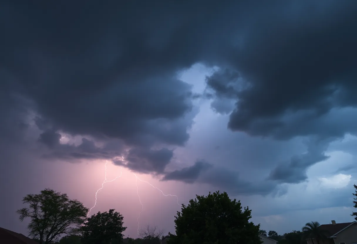
Hey there, folks in and around Laurens, Union, and Chester counties! It’s time to pay attention because Mother Nature is gearing up to put on quite a show. The National Weather Service (NWS) has issued a severe thunderstorm warning that started at 3:59 p.m. on Tuesday, and it runs until 4:45 p.m. If you’ve got plans outside, you might want to rethink them!
What to Expect from the Storm
As we look into what this storm is bringing, forecasters are predicting wind gusts that could reach up to 40 mph, which is strong enough to cause some serious mischief. Imagine those tree limbs swaying and unsecured items flying around! That’s right, if you’ve got anything loose outside, it might be a good idea to bring it in quickly.
But it gets even more interesting! According to the radar, a strong thunderstorm was spotted just 8 miles southwest of Union, near the picturesque Rose Hill State Park. It’s on the move, heading northeast at a brisk 30 mph. So it might be just a matter of time before it starts making its presence felt right where you are!
Prepare for Hail
Brace yourselves, because the forecast also mentions the possibility of marble-sized hail, measuring up to 0.5 inches. You might want to consider parking your cars under some shelter. Minor damage to outdoor items like plants and furniture is also on the cards, so if you care about your backyard decor, now’s the time to take action!
Where is This Affected?
This storm is set to impact various locations in the area, including Cross Keys, Rose Hill State Park, Leeds, Lockhart, and even Buffalo. If you’re in any of these places, keep an eye on the sky and listen for updates. Safety should always come first!
Lightning and Safety Tips
Speaking of danger, remember that thunderstorms bring a high risk of lightning. The United States sees about 25 million lightning strikes annually, with a good chunk of those happening during the summer months. On average, around 20 people lose their lives each year due to lightning strikes. Yikes!
The NWS emphasizes that the safest place to be during a thunderstorm is inside a sturdy building. If you find yourself outdoors and can’t find shelter, there are still steps you can take to protect yourself. Avoid isolated trees, radios, and tall structures if you can help it.
Road Safety Concerns
As the rain starts pouring, driving conditions may become hazardous. Ever heard of hydroplaning? It happens when your vehicle skids uncontrollably on wet roads. This occurs because water accumulates faster than your car can push it out of the way. It’s a recipe for disaster, so be extra cautious if you’re on the road when the storm hits!
Stay Safe Out There!
The most important thing is to stay informed and prioritize your safety. Keep an eye on the weather updates, and don’t hesitate to seek shelter when needs be. We’ve got to look out for one another. So let’s all weather this storm safely!
Remember, storms like this can pack a punch, but with the right preparations and awareness, we can all get through it without a hitch. Keep safe, everyone!
Deeper Dive: News & Info About This Topic
HERE Resources
South Carolinians Brace for Weather Shift as Cold Front Approaches
Tragedy Strikes in Lancaster County
High School Football Teams Gear Up for 2025 Keep Pounding Classic
York County Faces Severe Thunderstorm Warning
Severe Weather Advisory Issued for Mecklenburg County
Chester County Braces for Severe Thunderstorm Chaos
Strong Thunderstorm Alert Hits Upstate South Carolina
Tragedy Strikes Rock Hill, SC: Third Fire Fatality in Recent Days
Charlotte Region Braces for Heavy Rain on Monday
Tragic Fires Claim Three Lives in Rock Hill
Additional Resources
- Herald Online
- Wikipedia: Severe Thunderstorm Warning
- Myrtle Beach Online
- Google Search: Thunderstorm Safety
- WYFF4 News
- Google Scholar: Thunderstorm Warnings
- WSPA News
- Encyclopedia Britannica: Thunderstorm
- Times Union
- Google News: Tornado Warnings
Author: STAFF HERE ROCK HILL
The ROCK HILL STAFF WRITER represents the experienced team at HERERockHill.com, your go-to source for actionable local news and information in Rock Hill, York County, and beyond. Specializing in "news you can use," we cover essential topics like product reviews for personal and business needs, local business directories, politics, real estate trends, neighborhood insights, and state news affecting the area—with deep expertise drawn from years of dedicated reporting and strong community input, including local press releases and business updates. We deliver top reporting on high-value events such as the Come-See-Me Festival, Rock Hill Arts Festival, and motorsport events at the Rock Hill Velodrome. Our coverage extends to key organizations like the Rock Hill Chamber of Commerce and the Culture & Heritage Museums, plus leading businesses in manufacturing and technology that power the local economy such as 3D Systems and Comporium. As part of the broader HERE network, including HEREAiken.com, HEREBeaufort.com, HEREChapin.com, HERECharleston.com, HEREClinton.com, HEREColumbia.com, HEREGeorgetown.com, HEREGreenwood.com, HEREGreenville.com, HEREHiltonHead.com, HEREIrmo.com, HEREMyrtleBeach.com, HERENewberry.com, HERERockHill.com, and HERESpartanburg.com, we provide comprehensive, credible insights into South Carolina's dynamic landscape.


