News Summary
Upstate South Carolina is bracing for severe thunderstorms as the National Weather Service issues an alert. With wind gusts of up to 50 mph and potential hail, residents in areas including Greater Oconee, Anderson, and Greenville counties are advised to seek shelter. Doppler radar indicates storms moving swiftly, and safety is paramount. Possible hazardous conditions including hydroplaning on roads are expected. The stormy weather is anticipated to continue through the weekend alongside further rain into next week. Stay safe and remain informed!
Weather Alert Issued for Thunderstorms in Upstate South Carolina!
Hey there, Upstate South Carolina! Buckle up because we’ve got a stormy night ahead. The National Weather Service (NWS) in Greenville-Spartanburg has put out a weather alert that came in just last night at 11:33 p.m. and is effective until 12:30 a.m. on Saturday. So, what can you expect? Well, let’s dive right in!
What’s Happening?
Areas like Greater Oconee, Greater Pickens, Anderson, Abbeville, and Greenville counties are in the storm’s path. These thunderstorms are packing a punch with wind gusts that could reach up to 50 mph and hail that’s about the size of peas (around 0.25 inches). Yikes!
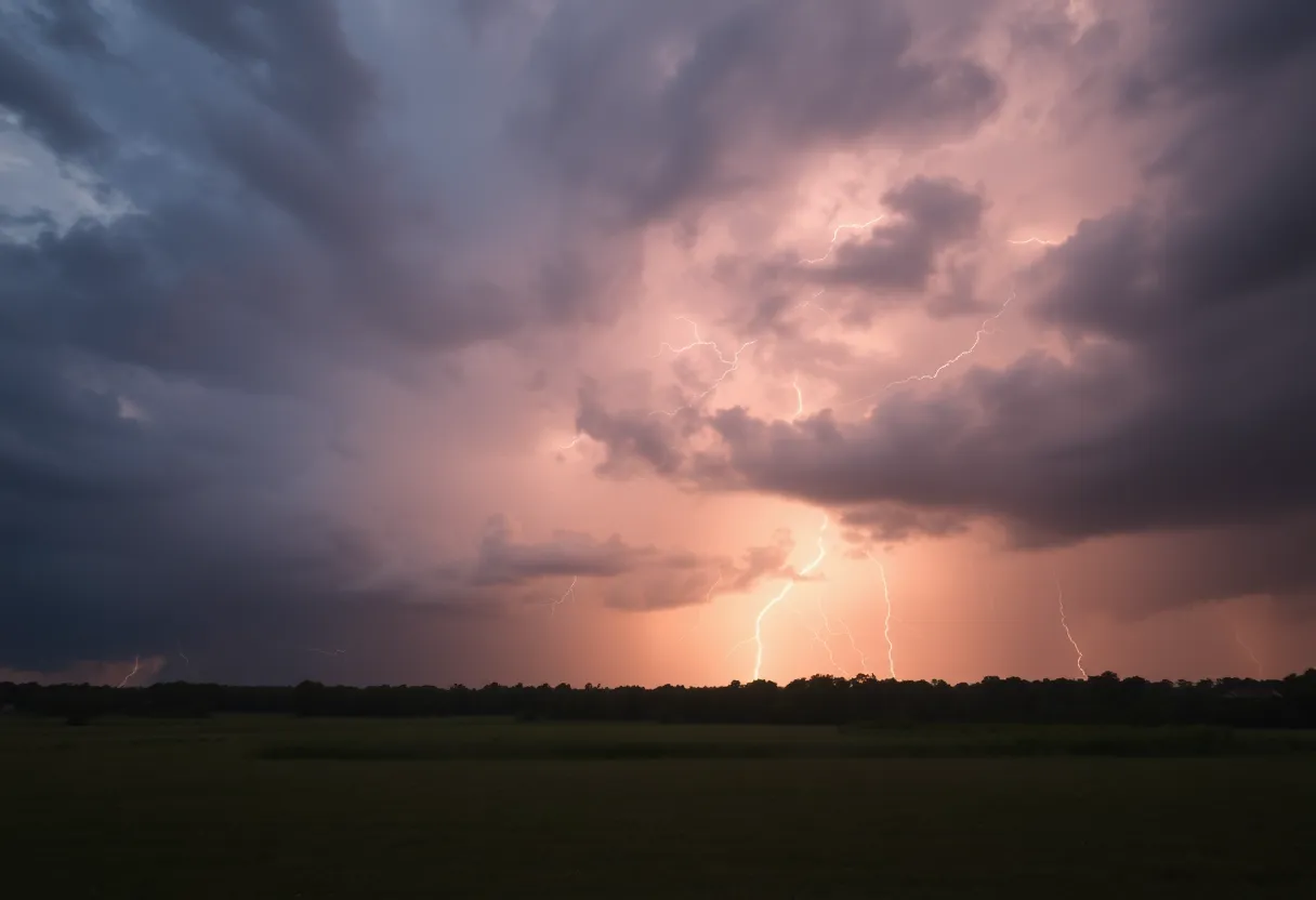
Doppler radar has picked up a wave of strong thunderstorms stretching from just southwest of Pickens to south of Hartwell, moving east at a brisk 35 mph. Keep your weather apps handy, folks! You don’t want to get caught out there without a heads-up on these wild winds and possible hail.
Safety First!
If you reside in places like Fork Shoals, Anderson Airport, Starr, Central, Powdersville, Northlake, Honea Path, Vanna, Norris, and Reed Creek, it’s time to head indoors if you weren’t already. The NWS strongly advises seeking shelter. If you’re on or near the lovely Lake Hartwell, it’s best to make your way out of the water and find some indoors space or hop into a vehicle.
Fun fact: Did you know that lightning can strike up to 10 miles away from a thunderstorm? So, if you can hear thunder, you’re already close enough to be in danger. In fact, lightning strikes the U.S. around 25 million times each year, mostly during summer, and can lead to about 20 fatalities annually. Stay smart and stay safe!
Road Conditions
For those of you planning to drive tonight, remember that if the roads get wet, there’s a chance of hydroplaning. This phenomenon happens when a vehicle might slide uncontrollably on wet roads thanks to the water building up in front of the tires. So, make sure you’re driving cautiously!
Upcoming Weather Forecast
Expect showers and more thunderstorms right through Tuesday evening, particularly around Spartanburg, along with those gusty winds and potential hail. By Tuesday night, we might catch a break with some dry hours, but don’t put the umbrella away just yet! More rain is likely to make a comeback on Wednesday and Thursday.
As we look towards the weekend, some isolated rain chances are also popping up on the forecast. If you’re planning to catch a game with the Hub City Spartanburgers baseball team, they’ve confirmed they will push through the rain, so keep an eye on their social media for updates!
Hazardous Weather Outlook
Heads-up! The NWS has issued a Hazardous Weather Outlook for the weekend. Expect heavy rain, severe storms, and even the possibility of tornadoes—especially in the Anderson, Greenville, and Spartanburg areas. Tonight into Sunday is likely to see just the perfect recipe for thunderstorms, with high chances for precipitation that could bring strong winds, large hail, and even tornado activity.
Stay tuned to your local weather updates, keep those emergency kits handy, and take care of each other out there! Let’s weather this storm together.
Deeper Dive: News & Info About This Topic
HERE Resources
Severe Thunderstorm Alert Issued for Midlands, SC
Thunderstorms Expected in Abbeville, Laurens, and Greenwood Counties
Strong Thunderstorm Warning Issued for Local Counties
Severe Thunderstorm Warning for Laurens, Union, and Chester Counties
South Carolinians Brace for Weather Shift as Cold Front Approaches
Fort Mill Grocery Store Incident Involving Armed Man
York County Faces Severe Thunderstorm Warning
Severe Weather Advisory Issued for Mecklenburg County
Chester County Braces for Severe Thunderstorm Chaos
Strong Thunderstorm Alert Hits Upstate South Carolina
Additional Resources
- WYFF 4: Weather Alert for Upstate South Carolina
- Island Packet: Upcoming Weather Forecast
- Goupstate: Spartanburgers vs. Drive Game Plans
- Greenville Online: Tornadoes Possible in Upstate SC
- Fox Carolina: Severe Thunderstorm Warning
- Wikipedia: Thunderstorm
Author: STAFF HERE ROCK HILL
The ROCK HILL STAFF WRITER represents the experienced team at HERERockHill.com, your go-to source for actionable local news and information in Rock Hill, York County, and beyond. Specializing in "news you can use," we cover essential topics like product reviews for personal and business needs, local business directories, politics, real estate trends, neighborhood insights, and state news affecting the area—with deep expertise drawn from years of dedicated reporting and strong community input, including local press releases and business updates. We deliver top reporting on high-value events such as the Come-See-Me Festival, Rock Hill Arts Festival, and motorsport events at the Rock Hill Velodrome. Our coverage extends to key organizations like the Rock Hill Chamber of Commerce and the Culture & Heritage Museums, plus leading businesses in manufacturing and technology that power the local economy such as 3D Systems and Comporium. As part of the broader HERE network, including HEREAiken.com, HEREBeaufort.com, HEREChapin.com, HERECharleston.com, HEREClinton.com, HEREColumbia.com, HEREGeorgetown.com, HEREGreenwood.com, HEREGreenville.com, HEREHiltonHead.com, HEREIrmo.com, HEREMyrtleBeach.com, HERENewberry.com, HERERockHill.com, and HERESpartanburg.com, we provide comprehensive, credible insights into South Carolina's dynamic landscape.

