News Summary
Residents of York and Chester counties are under severe thunderstorm warnings issued by the National Weather Service. The alert is in effect until 9 p.m., with thunderstorms expected to bring penny-sized hail, wind gusts up to 60 mph, and localized flooding. Residents are advised to seek shelter and stay indoors to avoid possible damage from strong winds and lightning strikes. Precautions should be taken if driving, as hydroplaning may occur on wet roads. Stay tuned for updates as conditions may worsen this evening.
Severe Thunderstorm Warnings Affect York and Chester Counties
Residents of York and Chester counties, get ready! The National Weather Service (NWS) just issued a serious severe thunderstorm warning starting at 8:13 p.m. this Tuesday. The warning is valid until 9 p.m., so keep your eyes peeled and stay safe!
What’s Happening?
As of 8:13 p.m., Doppler radar was tracking a strong thunderstorm about 5 miles southeast of York, moving east at a brisk 20 mph. This storm is not to be taken lightly; it could bring penny-sized hail (that’s 0.75 inches, for those wondering) and gusty winds hitting up to 40 mph. So, keep that in mind if you’re planning to head outdoors this evening!
Where You Might Be Affected
If you live in or around Newport, Lesslie, Catawba, York, Edgemoor, McConnells, Rock Hill, or Fort Mill, you should pay special attention. The storm could easily knock down tree limbs and toss around unsecured objects, so make sure your patio furniture is stowed away!
Safety First!
For those who are currently outside, the NWS strongly advises you to seek shelter in a sturdy building. The severe thunderstorm isn’t just about wind and hail; it’s also bringing along some serious rain that could lead to localized flooding. Remember, if you’re driving during these storms, avoid flooded roadways like the plague.
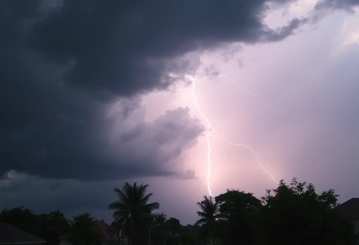
Lightning Strikes
This storm comes with frequent cloud-to-ground lightning, which can strike up to ten miles away from the thunderstorm. With about 25 million lightning strikes hitting the U.S. every year and causing around 20 fatalities, it’s crucial to stay indoors until the storm passes. Better to be safe than sorry!
What’s Changing?
There is an updated severe thunderstorm warning that was released at 8:18 p.m. Now it’s specifically for York County, effective until 8:30 p.m. Recent data shows that the severe thunderstorm is now moving a bit faster, at 25 mph, and wind gusts may reach up to 60 mph. Yes, you read that right – this storm might be more powerful than initially thought!
Brace for Impact!
Follow the Forecast
And as if tonight wasn’t eventful enough, local forecasts hint that thunderstorms might keep plunging through the area into the evening. Expect the rain and storms to continue their dance throughout the weekend with varying chances and temperatures.
Driving Caution
If you find yourself on the road, be extra careful. Hydroplaning can happen if your vehicle slides on wet roads because of water pressure building under the tires. Keep your speed in check, check your tire tread depth, and be aware of the water depth on the roadway!
So folks, stay indoors, stay informed, and may you all ride out this storm safely. Keep your loved ones close, your pets indoors, and keep an eye on the weather updates!
Deeper Dive: News & Info About This Topic
HERE Resources
Severe Thunderstorm Warning Issued for Cherokee and Spartanburg Counties
Rock Hill Man Arrested for Stabbing Pregnant Woman
Severe Thunderstorm Warning for Bamberg and Orangeburg Counties, SC
Severe Thunderstorm Alert for Rowan and Cabarrus Counties
Severe Thunderstorms Brewing in Upstate South Carolina
Severe Weather Alerts Issued for Columbia Residents
Severe Weather Disrupts Carolinas and Georgia
NC State Women’s Cross Country Team Wins Eighth Regional Title
Severe Thunderstorm Alert Shakes Up Chesterfield County
Severe Thunderstorm Warnings in South Carolina and Georgia
Additional Resources
- The State
- Wikipedia: Thunderstorm
- Island Packet
- Google Search: Thunderstorm Preparedness
- York Daily Record
- Google Scholar: Thunderstorm Warnings
- The New York Times
- Encyclopedia Britannica: Thunderstorm
- PennLive
- Google News: Severe Thunderstorm Warnings
Author: STAFF HERE ROCK HILL
The ROCK HILL STAFF WRITER represents the experienced team at HERERockHill.com, your go-to source for actionable local news and information in Rock Hill, York County, and beyond. Specializing in "news you can use," we cover essential topics like product reviews for personal and business needs, local business directories, politics, real estate trends, neighborhood insights, and state news affecting the area—with deep expertise drawn from years of dedicated reporting and strong community input, including local press releases and business updates. We deliver top reporting on high-value events such as the Come-See-Me Festival, Rock Hill Arts Festival, and motorsport events at the Rock Hill Velodrome. Our coverage extends to key organizations like the Rock Hill Chamber of Commerce and the Culture & Heritage Museums, plus leading businesses in manufacturing and technology that power the local economy such as 3D Systems and Comporium. As part of the broader HERE network, including HEREAiken.com, HEREBeaufort.com, HEREChapin.com, HERECharleston.com, HEREClinton.com, HEREColumbia.com, HEREGeorgetown.com, HEREGreenwood.com, HEREGreenville.com, HEREHiltonHead.com, HEREIrmo.com, HEREMyrtleBeach.com, HERENewberry.com, HERERockHill.com, and HERESpartanburg.com, we provide comprehensive, credible insights into South Carolina's dynamic landscape.