News Summary
On Thursday afternoon, South Carolina residents were warned to take cover as the National Weather Service issued a severe thunderstorm warning for several counties, including Beaufort and Jasper. The storm, moving at 35 mph, is expected to bring wind gusts of up to 50 mph and penny-sized hail. Residents in affected areas are urged to stay alert and secure outdoor items to prevent damage. Driving conditions may become hazardous due to hydroplaning risks. Safety precautions are advised as thunderstorms can pose risks from lightning and falling debris.
Severe Thunderstorm Warning Sweeps Through South Carolina
As the clock ticked toward the late afternoon on Thursday, residents of South Carolina were urged to take cover as the National Weather Service (NWS) issued a severe thunderstorm warning for several counties. This advisory, which started at 4:24 p.m. and is set to last until 5:15 p.m., covers areas including Inland Colleton, Inland Jasper, Coastal Colleton, Coastal Jasper, Hampton, and Beaufort counties.
What’s Coming Our Way?
Brace yourselves! Doppler radar has tracked a formidable thunderstorm near Pocotaligo, currently moving northeast at a brisk pace of 35 mph. Forecasts indicate that these storms could unleash winds gusting up to a whopping 50 mph along with penny-sized hail that measures around 0.75 inches. Yikes! That’s enough to cause some concern for your garden gnomes and patio furniture!
Who’s Affected?
If you find yourself in Walterboro, Yemassee, White Hall, Hendersonville, Gardens Corner, Green Pond, Ritter, Sheldon, Pocotaligo, or McPhersonville, it’s time to stay alert. The warning area stretches all the way along I-95 in South Carolina, particularly between mile markers 28 and 56. So, if you’re planning to hit the road during this time, you might want to rethink your plans!
Stay Informed!
Now is a good time to stay connected! The NWS recommends everyone keep an eye on reliable updates through NOAA Weather Radio All Hazards, local TV stations, or trusted local news sources. It’s always better to be prepared than caught off guard!
Get Ready for the Storm!
The strong winds may cause tree limbs to fall, and you can bet that anything unsecured left outside may be tossed around like confetti. While we hope for the best, minor damage to outdoor items is definitely on the table. So, secure those lawn chairs and bring in any loose decorations!
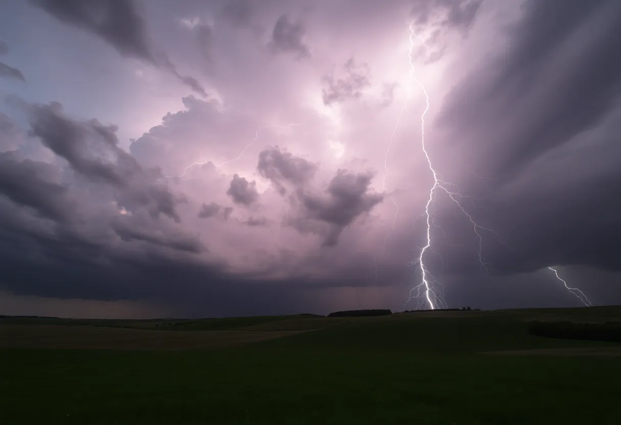
Take Cover from Lightning
As exciting as thunderstorms may sound, one thing worth noting is the dangers surrounding them. Lightning strikes across the U.S. around 25 million times each year, leading to an average of around 20 fatalities annually. Anyone outdoors needs to be extra cautious. The risk of lightning increases significantly as the storm approaches and peaks when it hovers directly overhead. So, if you can, seek shelter!
Tips for Staying Safe on the Road
If you’re on the road during this storm, be mindful of the risk of hydroplaning. This tricky situation happens when water builds up in front of your vehicle’s tires faster than your car can push it away, leading to loss of control. Factors like tire tread depth, speed, and the depth of water on the road can all contribute to the likelihood of hydroplaning. Drive slow and steady, and keep those windows rolled up!
Finding Shelter
For those unfortunate enough to be caught outdoors without proper shelter, safety should be your priority. Stay away from windows and avoid using any electrical appliances. It’s all about keeping yourself safe until the storm passes.
Remember, storms happen, but preparation is key to riding it out safely. Keep those ears open for updates, and don’t forget to check on your neighbors too. Stay safe, South Carolina!
Deeper Dive: News & Info About This Topic
HERE Resources
Severe Thunderstorm Watch Issued for South Carolina Counties
Severe Thunderstorms Hit South Carolina: Are You Prepared?
Severe Thunderstorms Hit Lowcountry of South Carolina
Severe Weather Alert: Thunderstorms Hit South Carolina and North Carolina
Severe Thunderstorms and Flooding Warnings Hit Charleston
Rock Hill Real Estate Market Stabilizes with Increased Inventory
Severe Thunderstorms Alert for Coastal South Carolina
NC State Cross Country Teams Shine at Regional Championships
York County, SC Experiences Dramatic Supercell Thunderstorm
Severe Thunderstorm Alerts in Oconee and Pickens Mountains
Additional Resources
- WXII 12 News
- Wikipedia: Thunderstorm
- Fox Weather
- Google Search: Thunderstorm Safety
- WYFF 4 News
- Google Scholar: Severe Weather Impact
- Live 5 News
- Encyclopedia Britannica: Severe Weather
- Grice Connect
- Google News: Severe Thunderstorm Warnings
Author: STAFF HERE ROCK HILL
The ROCK HILL STAFF WRITER represents the experienced team at HERERockHill.com, your go-to source for actionable local news and information in Rock Hill, York County, and beyond. Specializing in "news you can use," we cover essential topics like product reviews for personal and business needs, local business directories, politics, real estate trends, neighborhood insights, and state news affecting the area—with deep expertise drawn from years of dedicated reporting and strong community input, including local press releases and business updates. We deliver top reporting on high-value events such as the Come-See-Me Festival, Rock Hill Arts Festival, and motorsport events at the Rock Hill Velodrome. Our coverage extends to key organizations like the Rock Hill Chamber of Commerce and the Culture & Heritage Museums, plus leading businesses in manufacturing and technology that power the local economy such as 3D Systems and Comporium. As part of the broader HERE network, including HEREAiken.com, HEREBeaufort.com, HEREChapin.com, HERECharleston.com, HEREClinton.com, HEREColumbia.com, HEREGeorgetown.com, HEREGreenwood.com, HEREGreenville.com, HEREHiltonHead.com, HEREIrmo.com, HEREMyrtleBeach.com, HERENewberry.com, HERERockHill.com, and HERESpartanburg.com, we provide comprehensive, credible insights into South Carolina's dynamic landscape.