News Summary
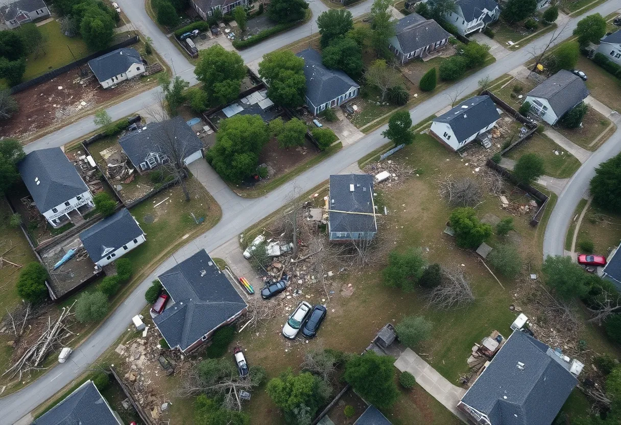
A brief tornado struck Rock Hill, SC, on Friday evening, leaving damage in its wake. Local meteorologists issued warnings as the storm approached, causing anxiety among residents. A video captured the tornado’s path on Percival Road, with damage reported to property and trees. The National Weather Service also warned of severe thunderstorms in the area, emphasizing the need for residents to seek safe shelter and stay informed during such dangerous weather patterns.
Rock Hill Faces Brief Tornado, Leaving Damage in Its Wake
This past Friday evening, the peaceful streets of Rock Hill, SC, were abruptly turned upside down as a brief tornado is believed to have swept through the area. Weather radar data strongly suggests that a tornado touched down, leaving a trail of damage and prompting local meteorologists to take note of the potential dangers of severe weather.
What Happened?
The tornado sighting was caught on tape by local resident Amber Burns Irvin. She filmed the alarming weather phenomenon along Percival Road, located just north of South Fork Road near Brattonsville. Irvin reported extensive damage to her barn, a playset, and several trees, showcasing how quickly nature can turn perilous.
According to meteorological data, the tornado appeared to spin up east of the McConnells community. Around 3:45 p.m., tornado warnings were issued for parts of Lancaster and Chesterfield counties, which made local residents very aware of the severity of the situation. These warnings expired at approximately 4:15 p.m., but the concern remained as severe thunderstorms were still expected to sweep through the Carolinas.
Storm Patterns and Their Implications
The storms were forecasted to develop from noon until 6 p.m., initially moving in from the mountains before making their way out of the area just in time for the evening commute. Some sections of the storm line were ripping through at speeds of up to 45 mph, causing even more anxiety among those already on edge from the tornado warnings.
In addition to the tornado concerns, the National Weather Service issued an updated tornado warning for Clarendon County at around 5:16 p.m. The warning was valid until 5:30 p.m., indicating a severe thunderstorm capable of producing a tornado over Santee Cooper Regional Airport. This storm was reportedly moving east at a brisk 60 mph. Residents were on high alert as the NWS warned of dangerous flying debris and the possibility of damage to mobile homes, roofs, windows, and vehicles.
Safety Precautions and Recommendations
The NWS stressed the necessity of acting promptly whenever a tornado warning is issued. Staying updated through local news sources or weather radio can significantly increase safety. The Federal Emergency Management Agency advises that everyone should keep a basic disaster supplies kit at home, which can be beneficial in emergency situations like this.
Recent Weather Patterns in the Region
This recent weather event comes on the heels of another alarming tornado sighting in the region. Just days earlier, an EF-1 tornado with winds reaching up to 90 mph was confirmed in Union County, causing damage to buildings and uprooted trees but thankfully resulted in no injuries. This tornado impacted areas close to Porter Ridge High School, creating a wake of destruction yet demonstrating nature’s unpredictability.
As Rock Hill assesses the damage and begins the recovery process, it’s crucial for everyone to stay vigilant and prepared for the ever-changing weather patterns characteristic of this time of year. As many residents are aware, severe weather can strike unexpectedly, and staying informed is the best defense.
Deeper Dive: News & Info About This Topic
HERE Resources
South Carolina Declares State of Emergency Amid Wildfires
Severe Thunderstorm Warning Hits South Carolina
Severe Thunderstorm Watch Issued for South Carolina Counties
Severe Weather Alert: Thunderstorms Hit South Carolina and North Carolina
Severe Thunderstorms and Flooding Warnings Hit Charleston
Severe Thunderstorms Alert for Coastal South Carolina
York County, SC Experiences Dramatic Supercell Thunderstorm
Severe Thunderstorm Alerts in Oconee and Pickens Mountains
Severe Thunderstorm Warning Issued for Cherokee and Spartanburg Counties
Severe Thunderstorms Brewing in Upstate South Carolina
Additional Resources
- WCNC: Possible Brief Tornado in York County
- Herald Online: Weather News Article
- Charlotte Observer: Weather News Insights
- Encyclopedia Britannica: Tornado
- Google Search: Tornado Severe Weather News
Author: STAFF HERE ROCK HILL
The ROCK HILL STAFF WRITER represents the experienced team at HERERockHill.com, your go-to source for actionable local news and information in Rock Hill, York County, and beyond. Specializing in "news you can use," we cover essential topics like product reviews for personal and business needs, local business directories, politics, real estate trends, neighborhood insights, and state news affecting the area—with deep expertise drawn from years of dedicated reporting and strong community input, including local press releases and business updates. We deliver top reporting on high-value events such as the Come-See-Me Festival, Rock Hill Arts Festival, and motorsport events at the Rock Hill Velodrome. Our coverage extends to key organizations like the Rock Hill Chamber of Commerce and the Culture & Heritage Museums, plus leading businesses in manufacturing and technology that power the local economy such as 3D Systems and Comporium. As part of the broader HERE network, including HEREAiken.com, HEREBeaufort.com, HEREChapin.com, HERECharleston.com, HEREClinton.com, HEREColumbia.com, HEREGeorgetown.com, HEREGreenwood.com, HEREGreenville.com, HEREHiltonHead.com, HEREIrmo.com, HEREMyrtleBeach.com, HERENewberry.com, HERERockHill.com, and HERESpartanburg.com, we provide comprehensive, credible insights into South Carolina's dynamic landscape.


