News Summary
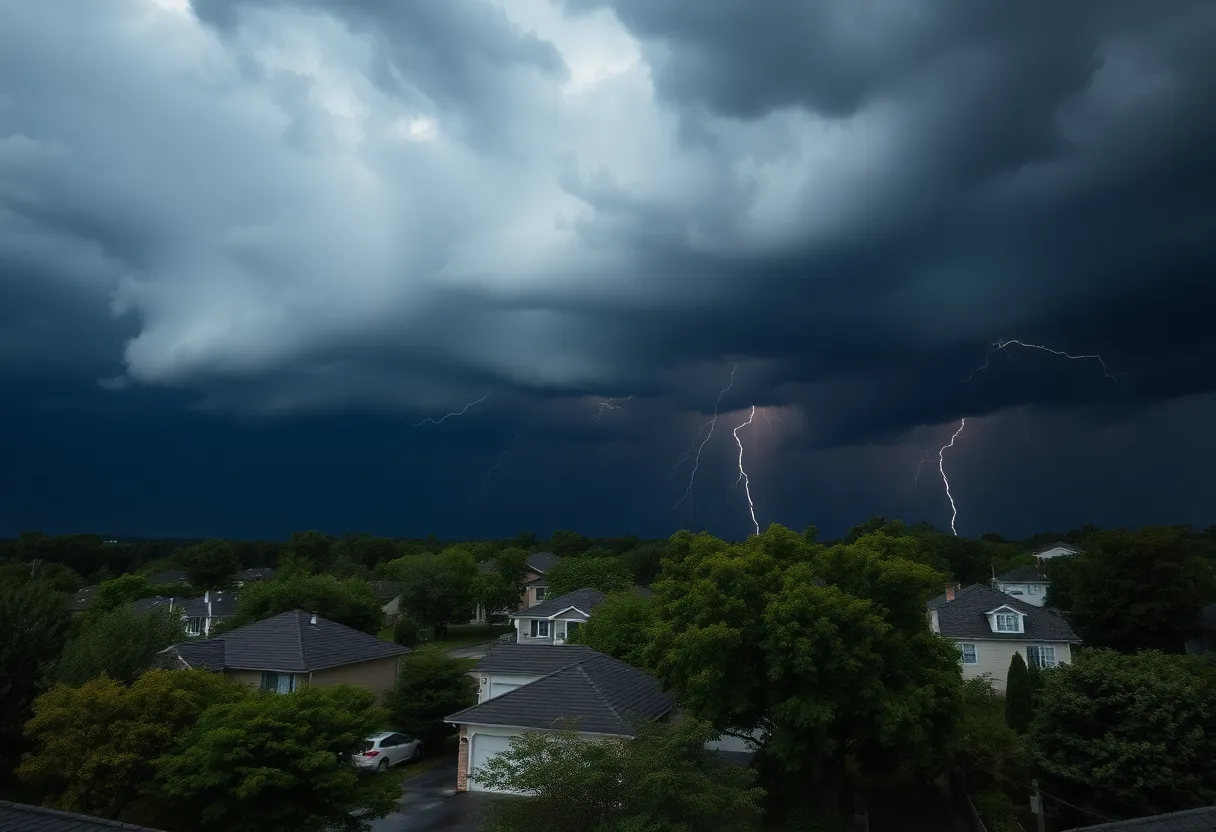
On Friday evening, severe thunderstorms prompted warnings for residents in Greenville and Spartanburg counties. The National Weather Service updated alerts predicting high winds and hail as storms approached. Wind gusts could reach 40 mph and hail expected to be marble-sized. Residents were urged to take cover due to frequent cloud-to-ground lightning and potential hazards from falling debris. This follows prior thunderstorm warnings earlier in the evening with similar risks. Staying informed is crucial as the storms move into the area.
Severe Thunderstorm Warnings Hit Greenville and Spartanburg Counties
As the sun dipped below the horizon on Friday evening, folks in Greenville and Spartanburg counties received some alarming news. The National Weather Service (NWS) sent out an updated alert at 9:23 p.m., indicating that strong thunderstorms were rolling in and expected to last until 10 p.m. A storm had been spotted just 4 miles northwest of Columbus, heading east at about 25 mph. Residents were urged to keep an eye on the skies as gusty winds and hail were on the way.
Wind and Hail Alert
So what exactly can people expect from these storms? Well, brace yourselves for wind gusts reaching up to 40 mph and hail the size of marbles (around 0.5 inches). While it may sound like a thrilling ride, these conditions could lead to some unwanted surprises, including fallen tree limbs and unsecured items being tossed about. Minor hail damage could also occur for outdoor possessions.
Areas particularly at risk include:
- Columbus
- Flat Rock
- Landrum
- Tryon
- Saluda
- Pleasant Ridge State Park
- Jones Gap State Park
- Caesars Head State Park
- Dupont State Forest
- Mill Spring
Take Cover!
If you happen to be outside when the storm strikes, the NWS strongly advises finding shelter indoors. The thunderstorm isn’t just about wind; it’s bringing along a lot of frequent cloud-to-ground lightning. This isn’t just your average light show; lightning can strike as far as 10 miles away from the storm. Did you know that in the United States, about 25 million lightning strikes occur each year? Unfortunately, they result in an average of 20 fatalities. So, when thunder rumbles, it’s time to hunker down!
Other Recent Alerts
This wasn’t the only warning on Friday. Earlier, at 7:47 p.m., another thunderstorm warning was issued for the Greater Pickens and Greenville County, where winds could gust up to 50 mph and hail the size of peas (about 0.25 inches). Doppler radar caught sight of a strong storm 12 miles northwest of downtown Greenville, near Slater-Marietta, also moving east at 25 mph.
Areas impacted by this earlier alert included:
- Travelers Rest
- Slater-Marietta
- Tigerville
- Lake Robinson
- Pleasant Ridge State Park
- Greer
- Paris Mountain State Park
- Caesars Head State Park
- Gowensville
- Cleveland
Previous Warnings
On June 1, a severe thunderstorm warning had already been issued at 5:53 p.m., indicating winds could soar up to 60 mph and hail could reach sizes of 1 inch in the area. This prior warning affected a wide range of locations, including:
- Reidville
- Five Forks
- Lake Robinson
- Lyman
- Greer
- GSP Airport
- Duncan
- Taylors
- Wellford
- Moore
Stay Informed and Stay Safe!
Residents are reminded to report any damaging winds, hail, or flooding to the National Weather Service. Whether you’re tucked up on the couch or just winding down your evening, keeping an eye on the weather can keep you safe.
As storms roll in, remember to stay informed, take shelter if needed, and keep those umbrellas handy—just in case! Stay safe out there, Greenville and Spartanburg!
Deeper Dive: News & Info About This Topic
HERE Resources
Thunderstorms Hit Anderson and Abbeville: Important Updates
Thunderstorm Chaos Strikes Myrtle Beach
Rock Hill, South Carolina Reports EF0 Tornado Without Injuries
Rock Hill, SC, Faces Short but Intense EF0 Tornado
Chesterfield County Faces Strong Thunderstorm Warnings
Brief Tornado Strikes Rock Hill, SC, Causes Damage
Severe Thunderstorm Alert Hits Coastal Georgia and South Carolina!
Severe Thunderstorm Warnings in York County
Rock Hill Tornado Causes Damage and Concern
Severe Thunderstorm Warning Hits South Carolina
Additional Resources
- WYFF4 News
- Wikipedia: Thunderstorm
- Herald Online
- Google Search: Thunderstorm Warnings
- Myrtle Beach Online
- Google Scholar: Severe Weather
- Greenville Online
- Encyclopedia Britannica: Thunderstorm
Author: STAFF HERE ROCK HILL
The ROCK HILL STAFF WRITER represents the experienced team at HERERockHill.com, your go-to source for actionable local news and information in Rock Hill, York County, and beyond. Specializing in "news you can use," we cover essential topics like product reviews for personal and business needs, local business directories, politics, real estate trends, neighborhood insights, and state news affecting the area—with deep expertise drawn from years of dedicated reporting and strong community input, including local press releases and business updates. We deliver top reporting on high-value events such as the Come-See-Me Festival, Rock Hill Arts Festival, and motorsport events at the Rock Hill Velodrome. Our coverage extends to key organizations like the Rock Hill Chamber of Commerce and the Culture & Heritage Museums, plus leading businesses in manufacturing and technology that power the local economy such as 3D Systems and Comporium. As part of the broader HERE network, including HEREAiken.com, HEREBeaufort.com, HEREChapin.com, HERECharleston.com, HEREClinton.com, HEREColumbia.com, HEREGeorgetown.com, HEREGreenwood.com, HEREGreenville.com, HEREHiltonHead.com, HEREIrmo.com, HEREMyrtleBeach.com, HERENewberry.com, HERERockHill.com, and HERESpartanburg.com, we provide comprehensive, credible insights into South Carolina's dynamic landscape.


