News Summary
On a typical Sunday morning, South Carolina residents were taken by surprise as severe thunderstorms descended upon the state, bringing high winds, hail, and widespread cancellations. The National Weather Service issued alerts predicting intense storms in several counties including Orangeburg and Calhoun. With gusts expected to reach 50 mph and reports of power outages affecting nearly 9,000 customers, safety measures were urged as damage was reported across highways and neighborhoods. As the storms moved offshore, a calmer week is anticipated ahead.
Severe Thunderstorms Sweep Through South Carolina
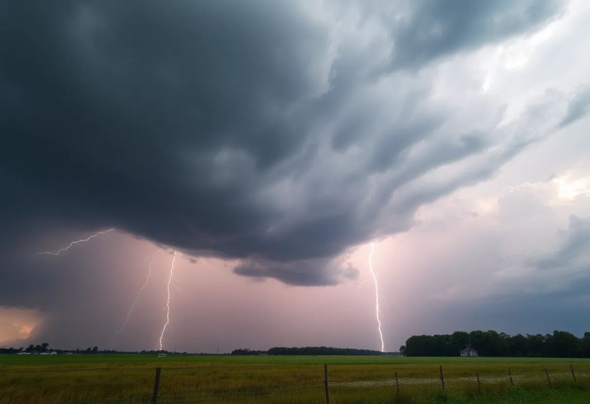
On a Sunday morning that started off like any other, residents across South Carolina were caught off guard as severe thunderstorms rolled in, bringing high winds, hail, and a flurry of cancellations. The National Weather Service in Columbia updated the alert just before 11:30 a.m., indicating that the storms were expected to kick into high gear from 11:29 a.m. until around 12:30 p.m.
Areas Affected
The storm’s reach was far and wide, impacting counties like Central Orangeburg, Southeastern Orangeburg, Calhoun, Clarendon, and Bamberg. Residents in cities including Orangeburg, Bamberg, Brookdale, Holly Hill, Branchville, Summerton, Bowman, and Elloree found themselves in the throes of strong winds and pea-sized hail.
Conditions to Brace For
As radar picked up on the severity of the storms, meteorologists noted that winds could gust as high as 50 mph and hail could be as large as 0.25 inches. These conditions posed significant threats, with gusty winds capable of knocking down tree limbs and sending unsecured items flying around, causing potential minor damage. Major highways bore the brunt of the weather, with parts of Interstate 26 and Interstate 95 particularly impacted.
Safety First
The National Weather Service urged everyone to take precautions and to seek shelter inside a sturdy building if they found themselves outdoors during the chaotic weather. With lightning striking the U.S. a staggering 25 million times annually—mostly during the summer months—it’s a reminder to keep safety top of mind.
Power Outages and Damage Reports
As the storms rolled through, reports started coming in about power outages across various counties. At the peak of the storm, nearly 9,000 customers in Lexington County were without power, while fallen trees and downed powerlines became common sights particularly in Calhoun and Orangeburg Counties. Highways like Highway 21 and Highway 6 were not spared, with reports of fallen trees blocking roads, making drives particularly hazardous.
Aftermath and Looking Ahead
Fortunately, the severe thunderstorm watch that expanded over several counties, including Charleston, Berkeley, and Dorchester, was eventually canceled as storms moved offshore. But the aftermath left a noticeable mark, with some areas experiencing extensive clean-up efforts to remove downed trees and quickly restore power.
After this bout of wild weather, folks can look forward to a calmer weekend ahead! Forecasters predict drier and more pleasant conditions, with temperatures expected to hover in the low 80s during the day and cool down to the upper 50s to low 60s at night. However, it’s worth keeping an eye on the sky, as there’s a chance for another round of severe weather on Sunday afternoon, before things finally start to settle down later in the weekend.
In Summary
So, South Carolina residents, stay safe, stay informed, and make sure to secure those outdoor items as the weather takes its rollercoaster ride. Whether you’re enjoying a sunny Sunday or dodging impending showers, let’s hope for a smooth transition into a beautiful, sunny week ahead!
Deeper Dive: News & Info About This Topic
HERE Resources
Severe Weather Action in Texas as Emergency Resources Mobilized
Minor Earthquake Hits South Carolina Near Elgin
Severe Thunderstorm Warning Issued for Upstate South Carolina
Severe Thunderstorm Warnings Sweep Across Upstate South Carolina
Severe Thunderstorms Sweep Through Columbia, Missouri
Severe Thunderstorm Alerts in Upstate South Carolina and Georgia
Severe Thunderstorm Warning for Greater Pickens and Greenville County
Severe Thunderstorm Warnings Impact Greenville and Spartanburg
Thunderstorms Hit Anderson and Abbeville: Important Updates
Limestone University to Close Charter Schools Impacting Students
Additional Resources
- The State
- Wikipedia: Severe Thunderstorm
- Herald Online
- Google Search: Severe Thunderstorms South Carolina
- Live 5 News
- Google Scholar: Thunderstorm Weather Warning
- WLTX
- Encyclopedia Britannica: Thunderstorm
- Island Packet
- Google News: South Carolina Weather Alerts
Author: STAFF HERE ROCK HILL
The ROCK HILL STAFF WRITER represents the experienced team at HERERockHill.com, your go-to source for actionable local news and information in Rock Hill, York County, and beyond. Specializing in "news you can use," we cover essential topics like product reviews for personal and business needs, local business directories, politics, real estate trends, neighborhood insights, and state news affecting the area—with deep expertise drawn from years of dedicated reporting and strong community input, including local press releases and business updates. We deliver top reporting on high-value events such as the Come-See-Me Festival, Rock Hill Arts Festival, and motorsport events at the Rock Hill Velodrome. Our coverage extends to key organizations like the Rock Hill Chamber of Commerce and the Culture & Heritage Museums, plus leading businesses in manufacturing and technology that power the local economy such as 3D Systems and Comporium. As part of the broader HERE network, including HEREAiken.com, HEREBeaufort.com, HEREChapin.com, HERECharleston.com, HEREClinton.com, HEREColumbia.com, HEREGeorgetown.com, HEREGreenwood.com, HEREGreenville.com, HEREHiltonHead.com, HEREIrmo.com, HEREMyrtleBeach.com, HERENewberry.com, HERERockHill.com, and HERESpartanburg.com, we provide comprehensive, credible insights into South Carolina's dynamic landscape.


