News Summary
Residents in Greenville and Spartanburg counties are under a severe thunderstorm watch. The National Weather Service warns of marble-sized hail and winds reaching up to 50 mph. Safety precautions are advised as conditions develop, with possible hydroplaning on roads. Stay indoors and secure loose items as storms approach. The weather is expected to impact various local areas, prompting urgent attention to safety measures.
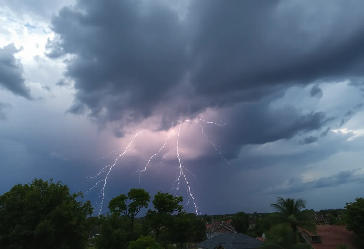
Thunderstorm Watch in Greenville and Spartanburg: Brace for Hail and Winds!
Residents of Greenville and Spartanburg counties, listen up! The National Weather Service (NWS) has just issued a severe thunderstorm warning that should make you perk up your ears. This alert came in just before 8:20 p.m. on Saturday evening, and it’s set to last until 9 p.m. So, make sure you’re prepared for some wild weather!
What’s Coming Our Way?
As the storm rolls in, you can expect some fierce conditions. The alerts warn of marble-sized hail that could reach about half an inch in size, and winds gusting up to a whopping 50 mph. If you think that’s just a gentle breeze, think again! Those wind speeds can easily knock down tree limbs and send unsecured items flying. So, it’s time to tie down those patio chairs and bring in any decorations that could turn into projectiles.
Don’t Let It Catch You Off Guard!
Just a tick before 8:20 p.m., the Doppler radar picked up on a robust thunderstorm that was about 12 miles northeast of downtown Greenville. This storm is moving eastward at a leisurely pace of around 15 mph. It’s headed toward various areas, including Greer, Duncan, Lyman, and, of course, the scenic Lake Robinson.
Safety First!
If you’re out and about, it’s highly advisable to seek shelter inside a sturdy building. Thunderstorms can bring not only rain and winds but also perilous lightning. Did you know that lightning strikes the United States approximately 25 million times every year, especially during the summer months? On average, around 20 fatalities occur annually due to lightning. So, take this seriously!
Watch Out for Hydroplaning!
One other thing to keep in mind is hydroplaning—this is when a vehicle begins to slide uncontrollably on wet roads. It can happen due to a build-up of water in front of the tires, and chances of it happening increase as you speed up. Remember, hydroplaning can be caused by three main factors: the speed of your vehicle, the depth of the water, and the tread condition of your tires. Stay alert, especially if you’re driving during or after the thunderstorm.
Earlier Warnings
Earlier on Saturday, at around 7:42 p.m., severe weather warnings had already been issued for Anderson, Greenville, Laurens, Pickens, and Spartanburg counties, highlighting similar concerns. Wind speeds reached an alarming 60 mph, with hail reaching up to 0.75 inches. That’s no small potatoes!
Stay Inside, Stay Safe!
As the storm clouds gather, remember the NWS advice: if a severe storm rolls in, it’s best to retreat to an interior room on the lowest floor of your building. Keeping yourself, your family, and your pets safe should be the priority!
What’s Next?
Keep an eye on the skies, folks! With more storms likely on the horizon, these warnings are based on radar indications and historical data about storm patterns. Precautions will help you weather any storm. If you’re in the affected areas or planning to go outside, consider packing up for the evening and staying cozy indoors.
Stay safe and keep your loved ones safe during this stormy weather. Let’s hope this thunderstorm passes swiftly!
Deeper Dive: News & Info About This Topic
HERE Resources
Woman Arrested in Hit-and-Run Death of Bicyclist in York
Severe Thunderstorm Alert in South Carolina
Severe Weather Wreaks Havoc in Columbia, South Carolina
Anderson, South Carolina Faces Severe Thunderstorm Warning
Severe Thunderstorm Alerts Issued for South Carolina
Severe Thunderstorm and Tornado Alerts Cause Concern in the CSRA
Myrtle Beach Faces Severe Thunderstorm Warnings
Severe Thunderstorm Alert Rocks Charleston Area
Severe Thunderstorm Warning Issued for Orangeburg, Lexington, and Aiken Counties
Severe Thunderstorm Warnings Issued for Upstate South Carolina
Additional Resources
- Island Packet
- Wikipedia: Thunderstorm
- Greenville Online
- Google Search: Severe Thunderstorm Warnings
- Independent Mail
- Encyclopedia Britannica: Thunderstorm
- Fox Carolina
- Google News: Thunderstorm Weather
Author: STAFF HERE ROCK HILL
The ROCK HILL STAFF WRITER represents the experienced team at HERERockHill.com, your go-to source for actionable local news and information in Rock Hill, York County, and beyond. Specializing in "news you can use," we cover essential topics like product reviews for personal and business needs, local business directories, politics, real estate trends, neighborhood insights, and state news affecting the area—with deep expertise drawn from years of dedicated reporting and strong community input, including local press releases and business updates. We deliver top reporting on high-value events such as the Come-See-Me Festival, Rock Hill Arts Festival, and motorsport events at the Rock Hill Velodrome. Our coverage extends to key organizations like the Rock Hill Chamber of Commerce and the Culture & Heritage Museums, plus leading businesses in manufacturing and technology that power the local economy such as 3D Systems and Comporium. As part of the broader HERE network, including HEREAiken.com, HEREBeaufort.com, HEREChapin.com, HERECharleston.com, HEREClinton.com, HEREColumbia.com, HEREGeorgetown.com, HEREGreenwood.com, HEREGreenville.com, HEREHiltonHead.com, HEREIrmo.com, HEREMyrtleBeach.com, HERENewberry.com, HERERockHill.com, and HERESpartanburg.com, we provide comprehensive, credible insights into South Carolina's dynamic landscape.

