News Summary
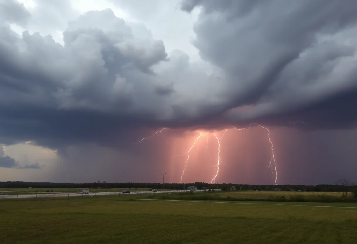
York County is on alert as the National Weather Service has issued severe thunderstorm warnings due to an approaching storm with high winds and hail. The warning began at 7:12 p.m. and is expected to last until 7:45 p.m. Residents in Rock Hill, Fort Mill, and surrounding areas should seek shelter and stay informed about the storm’s developments as wind gusts of 60 mph and penny-sized hail are anticipated.
Severe Thunderstorm Warnings Issued for York County as Storms Approach with High Winds and Hail
York County is bracing for a significant thunderstorm as the National Weather Service (NWS) Greenville-Spartanburg SC has issued a warning to residents that started at 7:12 p.m. on Friday and will be in effect until 7:45 p.m.. This storm is expected to bring some serious weather, including strong winds and hail!
What’s Coming Your Way?
The forecast predicts wind gusts could reach up to 60 mph alongside penny-sized hail of about 0.75 inches. Residents should keep their eyes peeled as these severe thunderstorms are moving in from a line stretching from 12 miles northwest of Indian Land toward Rock Hill, at a speed of 15 mph.
Communities that may be affected by this storm include Rock Hill, Fort Mill, Tega Cay, Newport, Steele Creek, and even Lake Wylie, along with Carowinds and areas of Southwest Charlotte. The NWS is advising everyone, particularly those near the lake, to seek shelter immediately.
Stay Safe: Tips During the Storm
It’s crucial to stay safe while the storm passes. The NWS recommends finding shelter inside an interior room of your home, away from windows, where you can wait it out. If you’re enjoying the outdoors at Lake Wylie, it’s best to leave the water and get indoors or into a vehicle to stay safe from lightning.
Speaking of lightning, it’s important to remember that it can strike as much as 15 miles away from a thunderstorm. So if you hear *thunder*, you’re within striking distance—better to be safe than sorry!
Be Aware of Previous Weather Warnings
Interestingly, just a couple of days earlier, on Thursday, June 26, 2025, a similar severe thunderstorm warning was broadcast for southern York County until 6:15 p.m.. During that event, the storms were moving southeast at 20 miles per hour and brought with them quarter-sized hail (about 1 inch) and the same concerning wind gusts of up to 60 mph.
The earlier storm affected various locations such as Hanover, Codorus, Shrewsbury, Glen Rock, and Jacobus, and had an impact on Interstate 83 too, particularly from mile markers 0 to 14.
Driving Precautions: Hydroplaning Awareness
With all that rain and wind swirling about, safety on the roads must be a top priority! Hydroplaning is a genuine concern when precipitation begins. This happens when water builds up in front of a tire faster than the vehicle’s weight can push it out of the way, which can lead to loss of control. In fact, the first 30 minutes of rainfall tends to make roads the slickest due to a blend of rain, grime, and oil.
Stay vigilant, keep those vehicles steady, and ensure you’ve got a plan for safety. When severe weather heads your way, it’s all about staying informed and acting quickly!
In light of this severe thunderstorm, residents should keep monitoring the weather updates and follow safety guidelines to protect themselves. Let’s hope this storm passes quickly, leaving York County safe and dry!
Deeper Dive: News & Info About This Topic
HERE Resources
Severe Thunderstorm Warnings Hit York County
Severe Thunderstorm Warning Issued for Oconee County
Severe Thunderstorm Warning Issued for Greenville and Spartanburg
Severe Thunderstorm Warning Issued for York County
Thunderstorm Watch Issued for Abbeville and Greenwood Counties
Severe Thunderstorm Warning for York County Amid Heatwave
Severe Thunderstorm Warning Issued for Charleston Area
20 Swimmers Struck by Lightning in South Carolina Beach Park
Severe Thunderstorm Warnings Issued for Southeastern Orangeburg
Devastating Tornado Outbreak in North Dakota Claims Three Lives
Additional Resources
- Herald Online
- Wikipedia: Thunderstorm
- Island Packet
- Google Search: thunderstorm safety
- York Daily Record
- Google Scholar: severe thunderstorms
- WGAL
- Encyclopedia Britannica: Thunderstorm
- PennLive
- Google News: thunderstorm warnings
Author: STAFF HERE ROCK HILL
The ROCK HILL STAFF WRITER represents the experienced team at HERERockHill.com, your go-to source for actionable local news and information in Rock Hill, York County, and beyond. Specializing in "news you can use," we cover essential topics like product reviews for personal and business needs, local business directories, politics, real estate trends, neighborhood insights, and state news affecting the area—with deep expertise drawn from years of dedicated reporting and strong community input, including local press releases and business updates. We deliver top reporting on high-value events such as the Come-See-Me Festival, Rock Hill Arts Festival, and motorsport events at the Rock Hill Velodrome. Our coverage extends to key organizations like the Rock Hill Chamber of Commerce and the Culture & Heritage Museums, plus leading businesses in manufacturing and technology that power the local economy such as 3D Systems and Comporium. As part of the broader HERE network, including HEREAiken.com, HEREBeaufort.com, HEREChapin.com, HERECharleston.com, HEREClinton.com, HEREColumbia.com, HEREGeorgetown.com, HEREGreenwood.com, HEREGreenville.com, HEREHiltonHead.com, HEREIrmo.com, HEREMyrtleBeach.com, HERENewberry.com, HERERockHill.com, and HERESpartanburg.com, we provide comprehensive, credible insights into South Carolina's dynamic landscape.


