News Summary
Charleston County, SC, is under severe weather alerts as thunderstorms roll through the area, impacting communities such as North Charleston and Summerville. With risks of strong winds and frequent lightning, residents are urged to stay indoors and take precautions. The National Weather Service has extended warnings, and drivers in affected areas should exercise caution, especially on I-26. Important updates on public safety and flood advisories are also in the pipeline. Stay informed and prioritize safety during these tumultuous weather conditions.
Thunderstorm Warnings Hit Charleston County: Stay Safe!
Charleston County, SC, is bracing for some severe weather as the National Weather Service (NWS) has issued ongoing storm alerts that might make you want to check your windows and make sure those loose garden decorations are secure. Just as the clock struck 9:34 p.m. on Friday, an updated weather alert warned that strong thunderstorms were rolling through, expected to last until 10 p.m. for areas in Inland and Tidal Berkeley counties.
What’s Happening?
Doppler radar spotted a robust thunderstorm brewing over the charming community of Pinopolis, making its way southeast at a brisk pace of 20 miles per hour. This storm is not just a light drizzle – it comes with a risk of gusty winds that could easily take down tree limbs or send unsecured lawn items flying. If you’re anywhere near the coast, keep an eye out!
Areas Affected
The weather alert may very well affect your plans if you are in North Charleston, Summerville, Goose Creek, Moncks Corner, or even Bonneau. Travel along I-26 between mile markers 190 and 204 is also under the watchful eyes of the NWS, and drivers should be cautious in these conditions.
Extended Warnings
What’s Triggering All This?
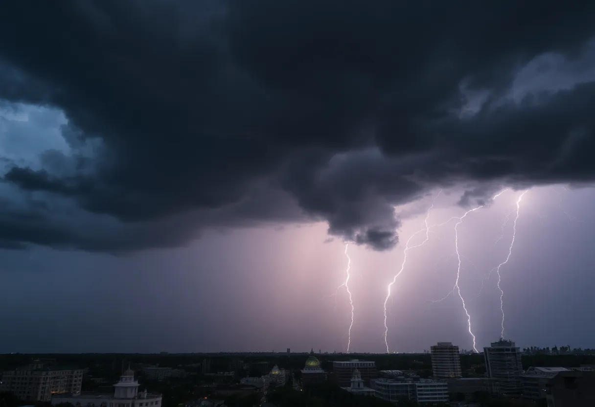
These thunderstorms come with a side of frequent cloud-to-ground lightning. If you think you are safe inside, think again: lightning can strike as much as 10 miles away from the storm itself! So, even as you enjoy the sound of rain, please remember to seek safe shelter inside a sturdy building or vehicle.
Understanding the Risk
With around 25 million lightning strikes hitting the United States every year, summer is typically the peak time, and sadly, those strikes can cause approximately 20 fatalities yearly. Lightning danger isn’t something to brush off lightly. As a thunderstorm rolls closer, the chances of a lightning strike can increase, peaking just when it’s overhead before subsiding as the storm drifts away.
What’s Next for Charleston?
The NWS, always obsessed with improving public safety, is also working on making changes to their flood advisories. In a move that aims to better align local alerts with national standards, they’re planning to implement new criteria for Flood Advisories and Flash Flood Warnings. This initiative hopes to make it clearer when residents should worry about flooding risks.
What this Means for Residents
So, what can you expect? Over the past year, Charleston’s NWS issued about 95 advisories and 19 warnings. With the new policy, those numbers could flip, offering more definitive warnings for urban areas that struggle with flooding. But don’t fret; these changes are not reflective of an increased flood risk but rather focus on clearer communication.
Stay Cautious!
It’s essential to stay informed and prepared during this stormy weather. If you’re out on the roads, be wary of hydroplaning, a situation where your tires lose contact with the wet surface, leading to a slippery ride. The NWS has provided guidance on how to respond if you find yourself hydroplaning, so make sure to familiarize yourself with those tips!
Remember, folks, safety is key during these thunderstorms. Keep your loved ones close, stay indoors if you can, and let’s weather this storm together!
Deeper Dive: News & Info About This Topic
HERE Resources
Severe Thunderstorms Strike South Carolina and Missouri
Severe Heat and Thunderstorms Expected in Maryland and New York
Southeast U.S. Faces Scorching Heat Wave
Strong Thunderstorm Warning Issued for South Carolina and Georgia
Severe Thunderstorm Warnings Hit Charleston, SC
Aiken County Faces Severe Weather with Thunderstorms and Tornadoes
Weather Alert: Strong Thunderstorms Hit Spartanburg and Union Counties
Severe Thunderstorm Alerts Hit Florence County: Stay Safe!
Myrtle Beach Residents Brace for Severe Thunderstorm Warning
Severe Thunderstorm Alert for Marlboro and Dillon Counties
Additional Resources
- Herald Online: Thunderstorm Warnings Hit Charleston County
- Wikipedia: Thunderstorm
- Island Packet: Severe Weather Updates
- Google Search: Thunderstorm Warning
- ABC News 4: Severe Thunderstorm Warnings
- Google Scholar: Thunderstorm Warning
- Fox Weather: Flood Alerts and Warnings
- Encyclopedia Britannica: Thunderstorm
- Count On 2: NWS Changes Flood Warnings
- Google News: Thunderstorm