News Summary
A Severe Thunderstorm Warning is in effect for Henderson County as strong storms approach. Residents are urged to take precautions, including seeking shelter and being cautious on the roads due to potential hydroplaning. Winds may gust up to 40 mph and lightning poses a significant threat. Stay informed and prepared as heavy rain and hail could accompany the storms. Keep an emergency kit handy and watch for updates until the warning expires at 8:45 p.m.
Severe Thunderstorm Warning for Henderson County: Brace for Impact!
Hey there, neighbors! If you’re soaking up the evening vibes in Henderson County, you might want to pay attention to the skies. A Severe Thunderstorm Warning has been issued as officials anticipate some serious weather rolling through.
The Scoop on the Storm
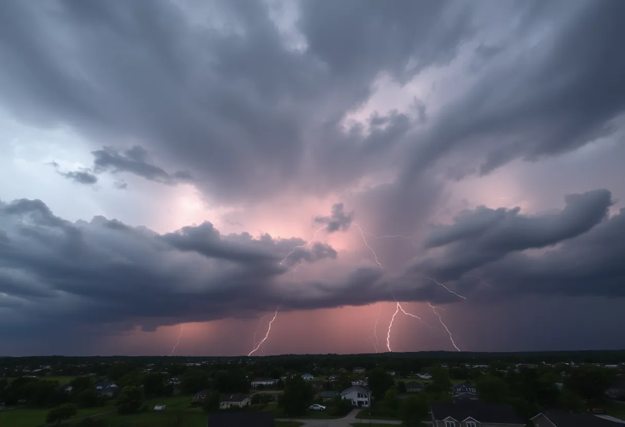
It all kicked off at 8:11 p.m. on Wednesday when the National Weather Service let us know that strong thunderstorms would be on the scene, sticking around until at least 8:45 p.m. If you look outside, you might notice some dark clouds gathering, and yes, that’s your cue to be cautious!
Doppler radar has picked up a storm that’s currently just 5 miles northwest of Hendersonville, close to Mills River, and it’s moving southward at a speed of 15 mph. So, if you’re in or around the affected areas—which include popular spots like Hendersonville, Mills River, Etowah, Mountain Home, Laurel Park, Fletcher, Flat Rock, Valley Hill, Horse Shoe, and Crab Creek—stay alert!
What to Expect
Residents are warned to watch out for wind gusts that could soar up to 40 mph. Such powerful gusts can easily send tree limbs flying and cause unsecured objects to be tossed about like confetti at a party. That’s no fun at all!
And hey, while we all love a good summer storm, remember that lightning can be a serious concern. In the U.S., there are about 25 million lightning strikes every year, most of which occur during the warmer months, leading to around 20 fatalities annually. As the thunderstorm approaches, the chance of a lightning strike can rise quickly, peaking when the storm is overhead before tapering off as the storm moves away.
Safety First!
The National Weather Service has some important tips for staying safe during these thunderstorms. If you’re outdoors, it’s highly advisable to find shelter inside a sturdy building. Don’t risk it!
Additionally, keep in mind that if you’re driving, the wet roads can turn treacherous quickly due to a phenomenon known as hydroplaning. This happens because water builds up in front of your tires, causing your vehicle to lose traction and float on a thin layer of water. Yikes! Being aware of the top factors that contribute to hydroplaning—and driving cautiously—is essential to keeping you and others safe on the road.
Stay Prepared!
The severe thunderstorm warning is in effect until 8:45 p.m., so be sure to keep an eye on the weather updates and grab that emergency kit if you haven’t already. The storm may bring in heavy rain, strong winds, and possibly hail, so it’s always better to be safe than sorry.
Let’s look out for each other during this wild weather! Share this information with friends and family, as many may not be tuned in to the latest weather alerts.
Stay safe, Henderson County! Trust us, tomorrow will be sunny again – and so will our spirits!
Deeper Dive: News & Info About This Topic
HERE Resources
Severe Thunderstorm Warnings Hit Charleston Area
Severe Thunderstorm Warnings Cause Widespread Damage in Spartanburg County
Severe Thunderstorms Strike Upstate South Carolina and East Tennessee
Severe Thunderstorm Warnings Issued for Upstate SC Counties
Severe Thunderstorm Warnings Hit Charleston, SC
Strong Thunderstorm Alerts Rumble Through Laurens County, SC
Weather Alert: Strong Thunderstorms Hit Spartanburg and Union Counties
Severe Thunderstorm Alert for Marlboro and Dillon Counties
Severe Thunderstorm Warning Issued for Henderson County
Severe Thunderstorm Warning Issued for South Carolina
Additional Resources
- Charlotte Observer: Severe Thunderstorm Warning
- Wikipedia: Severe Thunderstorm
- News & Observer: Weather News
- Google Search: Thunderstorm Safety
- The State: Weather Update
- Google Scholar: Thunderstorm Warnings
- Tryon Daily Bulletin: Severe Thunderstorm Warning
- Encyclopedia Britannica: Thunderstorm
- Live 5 News: Thunderstorm Alerts
- Google News: Thunderstorm Warnings 2025