News Summary
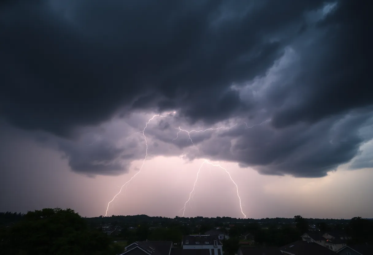
Residents in Anderson, South Carolina, should take precautions as the National Weather Service has issued a Severe Thunderstorm Warning. The warning is active until 9:45 p.m., with reports of high winds and potential hail. Areas like Honea Path and Due West are particularly at risk. This storm can lead to dangerous conditions, including lightning hazards and hydroplaning. Residents are advised to seek shelter and stay safe indoors as the storm approaches and impacts the broader region, including parts of northeastern Georgia.
Anderson, South Carolina Bracing for Severe Thunderstorm Activity
As the skies grow darker in Anderson, South Carolina, residents are keeping a close watch as the National Weather Service (NWS) has issued a Severe Thunderstorm Warning. This alert was put in place at 9:13 p.m. on Thursday and is expected to remain effective until 9:45 p.m. If you’re outdoor enjoying the evening, now is the perfect time to find some shelter!
What’s Happening?
A strong thunderstorm has been detected approximately 13 miles north of Abbeville and is traveling northeast at a speed of about 15 mph. The forecast predicts that this storm could bring hail the size of pea (0.25 inches) and wind gusts reaching up to 40 mph. This means that loose branches could be blown off trees, and any unsecured outdoor items might be tossed around like frisbees.
Areas Most Affected
This warning is particularly relevant for those in Honea Path and Due West. If you find yourself outdoors in these areas, it’s crucial to head indoors and seek shelter immediately. As always, thunderstorm conditions can lead to dangerous lightning. Did you know that there are around 25 million lightning strikes in the U.S. every year, mostly during the summer? That’s quite a number! As the storm approaches, be aware that lightning likelihood increases significantly, peaking when it’s almost directly overhead.
Hydroplaning and Road Safety
With the rain expected to pour, vehicles on the road might face another hazard: hydroplaning. This occurs when a vehicle loses traction, sliding on a layer of water on the road. To avoid this slippery situation, ensure your tires are in good condition, keep an eye on your speed, and stay tuned to the road conditions.
Severe Thunderstorm Watch Continues
For those in northeastern Georgia, along with Upstate South Carolina, a Severe Thunderstorm Watch is in effect until 11 p.m. EDT. The NWS is warning that **the storm’s intensity could escalate**, causing severe conditions and affecting areas including Anderson, Greenville, Laurens, Pickens, and Spartanburg counties.
Further Warnings
Potential Damage
With this storm’s fierce winds and hail, residents should prepare for potential damage to trees, power lines, and outdoor structures. Areas like Anderson, Elberton, and Hartwell could see significant impacts. Those near Lake Hartwell or northern Lake Russell should take real caution due to the increased risk of lightning. Staying indoors during such weather is the best choice!
Storm Impact Reports
Unfortunately, these storms have already caused issues, including reports of flooding, downed power lines, and fallen trees in some neighborhoods. Witnesses have expressed their astonishment at the rapid changes in the weather, with some sharing experiences of heavy rain switching to hail almost immediately.
Residents in affected areas should also be ready for possible power outages, as restoration might take longer than expected. Local authorities are working to address damage reports. To ensure a quick response, those living in regions impacted by the storm are encouraged to contact the NWS to report any severe weather-related incidents.
Stay Prepared!
As this weather situation unfolds, it’s essential to keep an eye on updates and stay safe. Grab your emergency kits, hunker down, and wait out the storm together with your friends and family. Stay tuned for any alerts and enjoy a cozy night indoors while the storm rages outside!
Deeper Dive: News & Info About This Topic
HERE Resources
Severe Thunderstorm Warnings Issued for Upstate South Carolina
Severe Thunderstorm Warnings in Upstate South Carolina
Severe Thunderstorm Warnings Sweep South Carolina: Stay Alert!
Severe Thunderstorms Sweep Through South Carolina
Severe Thunderstorm Warning Issued for Upstate South Carolina
Severe Thunderstorm Warnings Sweep Across Upstate South Carolina
Severe Thunderstorms Sweep Through Columbia, Missouri
Severe Thunderstorm Alerts in Upstate South Carolina and Georgia
Severe Thunderstorm Warning for Greater Pickens and Greenville County
Severe Thunderstorm Warnings Impact Greenville and Spartanburg
Additional Resources
- Independent Mail: Severe Thunderstorm Warning for Anderson County
- Greenville Online: Severe Thunderstorm Warning for Greenville County
- Knox News: Tornado Warning for Knox, Anderson, Loudon, and Roane Counties
- Wikipedia: Thunderstorm
- Fox Carolina: Tornado Warning Issued for Pickens County
- Google Search: Severe Thunderstorm Warning Anderson County
Author: STAFF HERE ROCK HILL
The ROCK HILL STAFF WRITER represents the experienced team at HERERockHill.com, your go-to source for actionable local news and information in Rock Hill, York County, and beyond. Specializing in "news you can use," we cover essential topics like product reviews for personal and business needs, local business directories, politics, real estate trends, neighborhood insights, and state news affecting the area—with deep expertise drawn from years of dedicated reporting and strong community input, including local press releases and business updates. We deliver top reporting on high-value events such as the Come-See-Me Festival, Rock Hill Arts Festival, and motorsport events at the Rock Hill Velodrome. Our coverage extends to key organizations like the Rock Hill Chamber of Commerce and the Culture & Heritage Museums, plus leading businesses in manufacturing and technology that power the local economy such as 3D Systems and Comporium. As part of the broader HERE network, including HEREAiken.com, HEREBeaufort.com, HEREChapin.com, HERECharleston.com, HEREClinton.com, HEREColumbia.com, HEREGeorgetown.com, HEREGreenwood.com, HEREGreenville.com, HEREHiltonHead.com, HEREIrmo.com, HEREMyrtleBeach.com, HERENewberry.com, HERERockHill.com, and HERESpartanburg.com, we provide comprehensive, credible insights into South Carolina's dynamic landscape.


