News Summary
On May 25, an EF-1 tornado struck Floyd, New Mexico, at 5:20 p.m. MDT, creating chaos for residents and damaging power poles and a nearby dairy facility. It traveled a 5.2-mile path with winds reaching 90 mph. The storm caused significant power outages but resulted in no reported injuries. Local residents are on alert for more severe weather as the National Weather Service predicts additional storms in the area, emphasizing the importance of preparedness for future weather events.
Floyd, New Mexico: EF-1 Tornado Brings Damage and Disruption
Residents of Floyd, New Mexico experienced a surprising twist of fate on the evening of May 25, when an EF-1 tornado made a quick but significant appearance. Affecting the area at around 5:20 p.m. MDT, the tornado danced its way through the countryside, causing various troubles for locals and a nearby dairy facility.
A Twisting Path
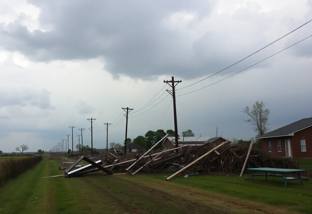
This tornado didn’t mess around. It touched down approximately 3 miles southwest of Floyd and chased a path to the northeast for an impressive 5.2 miles. Within just 17 minutes of its fiery arrival, it lifted off near Roosevelt Road 2, but not without leaving its mark along the way. With peak wind speeds reaching up to 90 mph, it carved a path up to 300 yards wide, leading to quite the scene for those nearby.
Power Problems
One of the most notable impacts was on the power supply in the area. It’s reported that the tornado snapped over 30 power poles during its brief but fierce descent. The devastation hit hardest near NM-267, where an estimated 10 to 15 poles fell victim to the storm, while around 20 poles were damaged along Roosevelt Road 3. It seems Mother Nature was showing no mercy.
Dairy Damage
The dairy facility in the vicinity didn’t escape unscathed either. Although the damage was mostly minor, it still created a headache for the management. The fencing took a hit, part of the metal roofing was affected, and to add to the chaos, their irrigation sprinkles got twisted into a mangled heap. Thankfully, no injuries were reported, allowing the community to breathe a sigh of relief amid the scary moments.
Spring Showers Bring Tornado Power
This EF-1 tornado was the most significant weather event that Roosevelt County saw during the spring of 2025, making it a date to remember in local weather history. Folks in the area are advised to stay vigilant, keeping their weather radios or mobile alerts at the ready for severe weather updates. No one likes surprises when it comes to mother nature’s antics, especially tornadoes, which can pop up unexpectedly.
More Storms Ahead
The excitement didn’t stop with just this tornado. The National Weather Service in Albuquerque isn’t waving the flag yet. They’re anticipating more spring storms in eastern New Mexico. Social media was buzzing with visuals showcasing heavy thunderstorms and alerts hinting at future weather threats nearby, particularly in areas like Clovis and Portales.
Severe Thunderstorm Warnings
In fact, the region wasn’t just on tornado watch; the NWS had severe thunderstorm warnings in place for multiple counties including Curry, Roosevelt, Colfax, and Union. Residents were also warned about large hail and the potential for damaging winds, sounding alarms for vehicles and structures in harm’s way. As rain gathered and winds howled, roads became risky with hail accumulation making travel even trickier.
As Floyd looks to recover from this unexpected weather event, the focus now shifts to preparedness. It’s a good reminder for everyone that mother nature can be unpredictable and a little precaution can go a long way in ensuring safety. With the threat of further storms looming, keeping an eye on the weather will certainly be a priority for residents in the coming weeks.
Deeper Dive: News & Info About This Topic
HERE Resources
Additional Resources
- KOAT: Floyd Tornado Survey
- Wikipedia: Tornado
- ABC 7: Tornado Touches Down in Eastern New Mexico
- Google Search: Floyd New Mexico tornado
- Weather.com: Timelapse Video Captures Tornado
- Encyclopedia Britannica: Tornado
- Hindustan Times: New Mexico Tornado Tracker
- Google News: New Mexico tornado
- KRQE: Tornado Touches Down Near Clovis
Author: STAFF HERE ROCK HILL
The ROCK HILL STAFF WRITER represents the experienced team at HERERockHill.com, your go-to source for actionable local news and information in Rock Hill, York County, and beyond. Specializing in "news you can use," we cover essential topics like product reviews for personal and business needs, local business directories, politics, real estate trends, neighborhood insights, and state news affecting the area—with deep expertise drawn from years of dedicated reporting and strong community input, including local press releases and business updates. We deliver top reporting on high-value events such as the Come-See-Me Festival, Rock Hill Arts Festival, and motorsport events at the Rock Hill Velodrome. Our coverage extends to key organizations like the Rock Hill Chamber of Commerce and the Culture & Heritage Museums, plus leading businesses in manufacturing and technology that power the local economy such as 3D Systems and Comporium. As part of the broader HERE network, including HEREAiken.com, HEREBeaufort.com, HEREChapin.com, HERECharleston.com, HEREClinton.com, HEREColumbia.com, HEREGeorgetown.com, HEREGreenwood.com, HEREGreenville.com, HEREHiltonHead.com, HEREIrmo.com, HEREMyrtleBeach.com, HERENewberry.com, HERERockHill.com, and HERESpartanburg.com, we provide comprehensive, credible insights into South Carolina's dynamic landscape.


