News Summary
The National Weather Service has issued a severe thunderstorm alert for Barnwell County, warning residents of heavy winds, potential tornado activity, flooding, and lightning. With wind gusts up to 55 mph expected and nearby tornadoes recently confirmed, residents are advised to secure loose items and seek shelter if necessary. The alert remains in effect until 6:45 p.m., and caution is urged on the road due to possible localized flooding and hydroplaning risks. Stay informed and prioritize safety during this severe weather event.
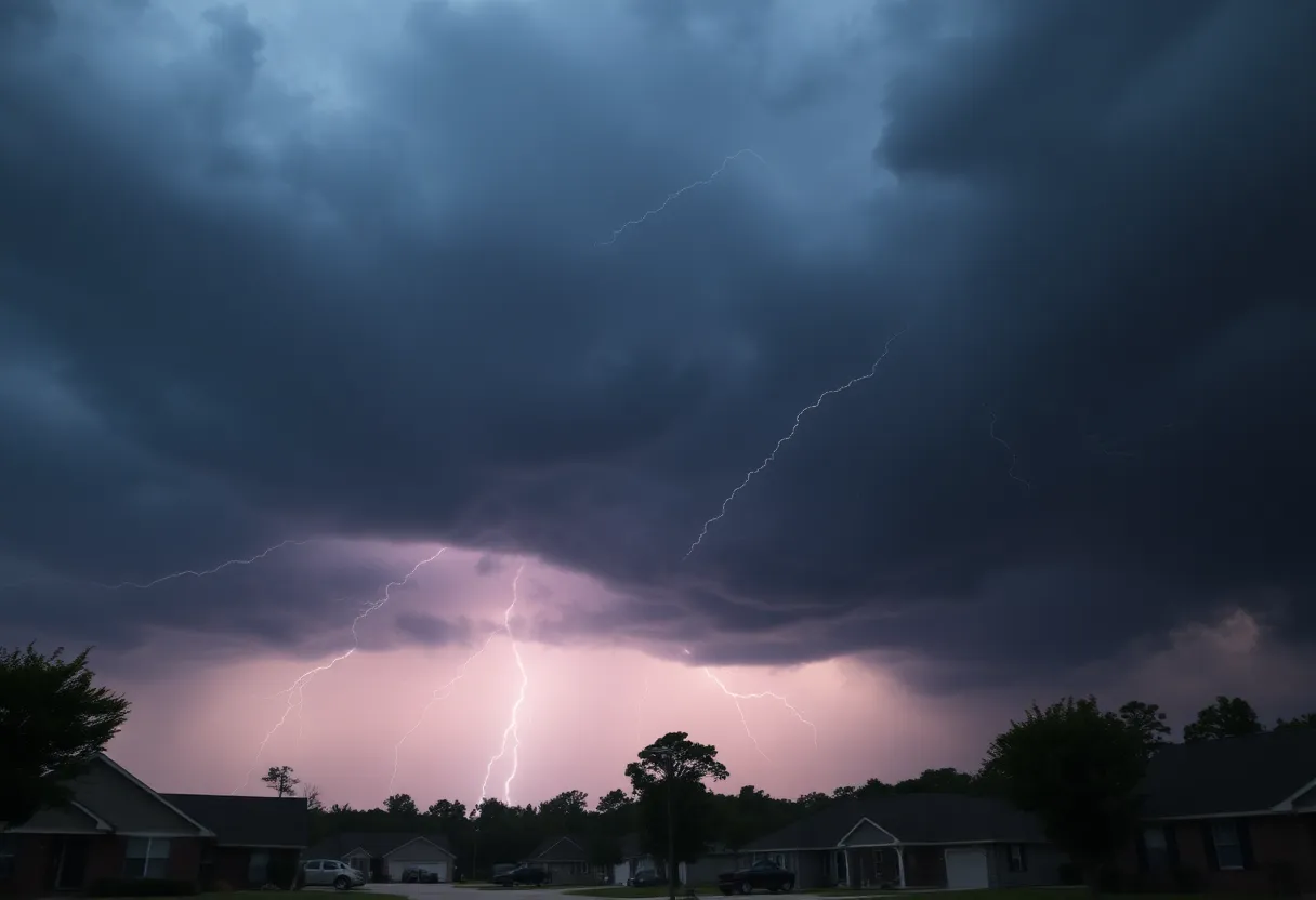
Severe Thunderstorm Alert: Stay Safe, Barnwell County!
Hey there, folks of Barnwell County! If you haven’t already heard, the National Weather Service (NWS) just issued an updated severe thunderstorm alert this Tuesday evening at around 6:02 p.m. With storms brewing up strong winds and even some tornado activity popping up in nearby areas, it’s essential to stay aware and prepare!
What to Expect
First things first, this alert lasts until 6:45 p.m., so you’ve still got some time to lock things down. Grab those loose items in your yard or patio, as winds could gust up to an impressive 55 mph. Keep in mind that these winds can easily break off tree limbs or send unsecured items flying.
As the NWS reported, Doppler radar has tracked some serious storm action from Wrens to Sardis, moving southeast at a pace of about 20 mph. That’s a fast and furious storm system headed our way!
Affected Areas
These thunderstorms are impacting several locations that are likely familiar to you. Some of those areas include:
- Waynesboro
- Plant Vogtle
- Hephzibah
- Sardis
- Midville
- Alexander
- Burke County Airport
- Gough
- Keysville
- Girard
- Vidette
- Di-Lane Wildlife Management Area
- Magruder
- Shell Bluff
- Colemans Lake
- Rosier
All of these regions are feeling the impact of the storm, so be cautious and stay indoors if you can. If you happen to be outside, it’s best to seek shelter until this squall passes.
Flooding and Lightning Concerns
Oh, and it’s not just the wind we’re concerned about! We’re expecting some torrential rainfall which could lead to localized flooding. So, if you’re out driving, make sure to avoid any flooded roadways because hydroplaning can become a very real threat. Many factors contribute to hydroplaning, including tire tread, speed, and how deep the water is on the road—so always use caution!
Did you know that lightning strikes the U.S. about 25 million times a year? Yes, you read that right! And while most occur during the summer, this is the season where the risk of lightning really ramp up. Stay alert, as the chances of a lightning strike go way up as storms roll in, especially when they’re right overhead.
Tornado Activity Nearby
Fortunately, no injuries were reported from these tornadoes, but they did leave quite a bit of destruction in their wake. Local communities have been stepping up to assist those affected, showcasing a true spirit of unity.
Your Safety is Key
Deeper Dive: News & Info About This Topic
HERE Resources
Strong Thunderstorm Warning Issued for South Carolina and Georgia
Severe Thunderstorm Warning Lifted for Orangeburg County
Severe Thunderstorm Warnings Impact Bamberg, Calhoun, and Orangeburg Counties
Severe Thunderstorm and Tornado Alerts Cause Concern in the CSRA
Severe Thunderstorm Warnings Sweep South Carolina: Stay Alert!
Severe Thunderstorm Watch Issued in South Carolina
Severe Thunderstorm and Tornado Warnings Hit Columbia
Severe Thunderstorm Warning in Orangeburg Area
Additional Resources
- Island Packet: Severe Weather Update
- Wikipedia: Severe Thunderstorm
- WJBF: Tornadoes Confirmed in CSRA
- Google Search: Tornadoes in South Carolina
- Spectrum Local News: Tornado Confirmed
- Encyclopedia Britannica: Tornado
- ABC Columbia: Storms Moving Through Midlands
- Google News: Weather Alerts
Author: STAFF HERE ROCK HILL
The ROCK HILL STAFF WRITER represents the experienced team at HERERockHill.com, your go-to source for actionable local news and information in Rock Hill, York County, and beyond. Specializing in "news you can use," we cover essential topics like product reviews for personal and business needs, local business directories, politics, real estate trends, neighborhood insights, and state news affecting the area—with deep expertise drawn from years of dedicated reporting and strong community input, including local press releases and business updates. We deliver top reporting on high-value events such as the Come-See-Me Festival, Rock Hill Arts Festival, and motorsport events at the Rock Hill Velodrome. Our coverage extends to key organizations like the Rock Hill Chamber of Commerce and the Culture & Heritage Museums, plus leading businesses in manufacturing and technology that power the local economy such as 3D Systems and Comporium. As part of the broader HERE network, including HEREAiken.com, HEREBeaufort.com, HEREChapin.com, HERECharleston.com, HEREClinton.com, HEREColumbia.com, HEREGeorgetown.com, HEREGreenwood.com, HEREGreenville.com, HEREHiltonHead.com, HEREIrmo.com, HEREMyrtleBeach.com, HERENewberry.com, HERERockHill.com, and HERESpartanburg.com, we provide comprehensive, credible insights into South Carolina's dynamic landscape.

