News Summary
Chesterfield County residents are advised to be on high alert as the National Weather Service has issued a Severe Thunderstorm Alert. Thunderstorms, expected until 3 p.m., could bring penny-sized hail and winds up to 50 mph. Key areas including Cheraw and Chesterfield are under warning, and residents should seek shelter. Moreover, power outages affecting over 19,000 customers are reported, with additional tornado warnings previously issued. Stay informed on the weather developments and ensure safety precautions are in place as the storm approaches.
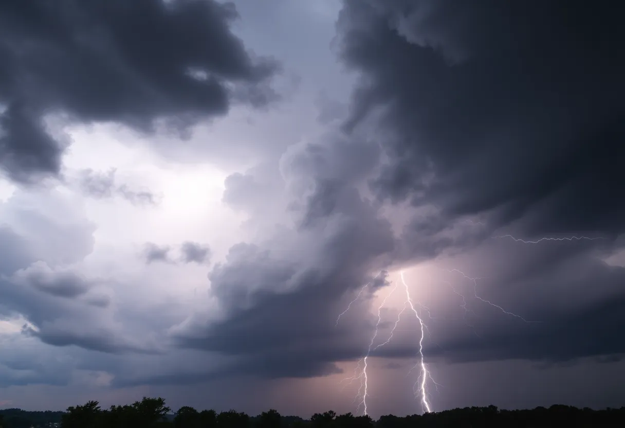
Severe Thunderstorm Alert Shakes Up Chesterfield County
Chesterfield County residents, buckle up! The National Weather Service (NWS) has issued a Severe Thunderstorm Alert that’s got everyone talking. The alert came out on Tuesday at 2:22 p.m., warning folks about some serious thunderstorms that will be affecting the area until around 3 p.m. It’s no joke, as these storms could rattle the region with penny-sized hail (that’s about 0.75 inches) and winds flying at speeds of up to 50 mph.
What’s Happening Right Now
Even right now, Doppler radar has picked up on a strong thunderstorm hanging out over Chesterfield, which is about 10 miles northwest of Cheraw. This storm is moving northeast at about 30 mph, creating quite a stir. Residents should keep an eye out, as gusty winds could easily knock down tree limbs and send unsecured items flying through the air. You might want to safely stow away any outdoor furniture or decorations in case of minor damages.
Key Areas to Watch
Practically the whole area of Chesterfield County is on alert. Places like Cheraw, Chesterfield, the Cheraw Municipal Airport, Northeastern Technical College, Ruby, McFarlan, Chesterfield Ruby Middle School, and the Chesterfield Detention Center are all bracing for the storm’s impact. If you’re outside when the storm hits, the NWS strongly advises finding a safe place indoors! Staying out in the storm isn’t just inconvenient; it could be dangerous.
Lightning and Hydroplaning: A Quick Reminder
Here’s a fun fact: every year in the U.S., lightning strikes about 25 million times. Most of those strikes happen during summer storms, and they sadly lead to about 20 fatalities annually, according to the NWS. As you might expect, lightning is more probable as a thunderstorm approaches, peaking when the storm is right overhead before tapering off afterwards. Remember, avoiding open fields and tall trees is crucial during lightning storms!
With all that rain comes another safety concern—hydroplaning. This occurs when your vehicle slides uncontrollably on wet surfaces, which is particularly common during storms. A good tip for avoiding it is to stay aware of the roadway conditions around you, and if you feel your car sliding, let off the gas and steer straight until you regain control.
Power Outages and More Warnings
In addition to the thunderstorm warning, it’s worth noting that last night, about 19,200 Dominion Energy customers found themselves without electricity, primarily impacting areas like Chesterfield, Henrico, Hopewell, and Richmond. It appears that these storms are causing quite a ruckus! Additionally, a tornado warning down in Central Virginia has expired, easing some worries, but it’s vital to remain vigilant as things develop.
Stay Tuned for Updates!
If you’re worried about the upcoming weather, no need to fret alone! Local meteorologists and the NWS are closely monitoring the situation, and they promise to keep everyone updated whenever there’s news to share. A squall line packed with heavier rain and thunder is coming our way, and gusts could exceed 60 mph—yikes! It’s also possible we may see isolated tornadoes, so let’s stay prepared and keep our eyes peeled for any further updates.
So, Chesterfield County, hang tight! Stay safe, stay indoors if possible, and don’t hesitate to make your place storm-ready. Here’s hoping the storm passes without too much fuss!
Deeper Dive: News & Info About This Topic
HERE Resources
South Carolina Faces Severe Thunderstorms and Tornado Watches
Heartbreaking Loss in Rock Hill: Community Supports School
Heartbreaking Fire Claims Lives of Local Family and Affects School Community
Severe Thunderstorm Watch Issued in South Carolina
Additional Resources
- Myrtle Beach Online
- Wikipedia: Thunderstorm
- 12 On Your Side
- Google Search: severe thunderstorm alerts
- WTVR
- Google Scholar: weather alerts
- Herald Online
- Encyclopedia Britannica: thunderstorm
- MLive
- Google News: thunderstorm severe weather
Author: STAFF HERE ROCK HILL
The ROCK HILL STAFF WRITER represents the experienced team at HERERockHill.com, your go-to source for actionable local news and information in Rock Hill, York County, and beyond. Specializing in "news you can use," we cover essential topics like product reviews for personal and business needs, local business directories, politics, real estate trends, neighborhood insights, and state news affecting the area—with deep expertise drawn from years of dedicated reporting and strong community input, including local press releases and business updates. We deliver top reporting on high-value events such as the Come-See-Me Festival, Rock Hill Arts Festival, and motorsport events at the Rock Hill Velodrome. Our coverage extends to key organizations like the Rock Hill Chamber of Commerce and the Culture & Heritage Museums, plus leading businesses in manufacturing and technology that power the local economy such as 3D Systems and Comporium. As part of the broader HERE network, including HEREAiken.com, HEREBeaufort.com, HEREChapin.com, HERECharleston.com, HEREClinton.com, HEREColumbia.com, HEREGeorgetown.com, HEREGreenwood.com, HEREGreenville.com, HEREHiltonHead.com, HEREIrmo.com, HEREMyrtleBeach.com, HERENewberry.com, HERERockHill.com, and HERESpartanburg.com, we provide comprehensive, credible insights into South Carolina's dynamic landscape.

