News Summary
The National Weather Service has issued a severe thunderstorm alert for Marlboro and Dillon Counties until 4:45 PM today. Thunderstorms, radar indicates, are moving in with the potential for pea-sized hail, heavy rain, and localized flooding. Residents in Pembroke, Maxton, and surrounding areas are urged to remain indoors due to lightning and the risk of hydroplaning while driving. The severe thunderstorm watch is expected to last until 10 PM tonight, leading to several rounds of rain and storms.
Severe Thunderstorm Alert Hits Marlboro and Dillon Counties!
Hey there, folks of Marlboro and Dillon Counties! Buckle up because we have a weather update for you that might just make you rethink your evening plans. The National Weather Service has just issued a severe thunderstorm alert effective until 4:45 PM today. So, if you haven’t heard yet, it’s time to pay attention to the skies!
What to Expect
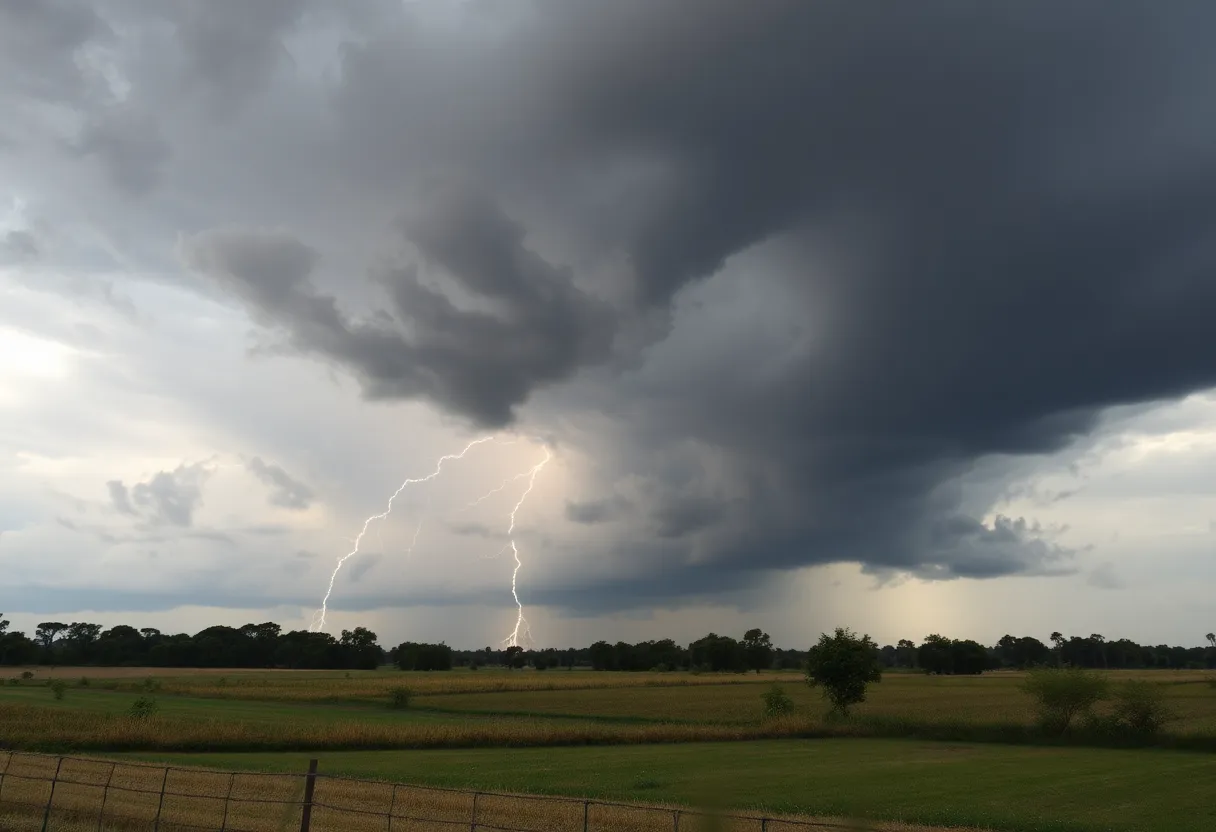
Starting around 4:11 PM, strong thunderstorms are rolling into the area, and let’s just say they come with a few surprises! Radar is showing a cluster of thunderstorms near Clio, which is about 10 miles east of Bennettsville. They’re moving northeast at about 25 miles per hour. So, if you’ve got outdoor activities planned, you might want to hit the brakes and think twice!
Be prepared for pea-sized hail—yes, we’re talking about those tiny but mighty ice balls that can cause some minor damage, especially to your precious plants. To make matters more interesting, these storms are ready to unleash some heavy rain, resulting in localized flooding in certain spots. So if you’re out and about, it’s best to find some shelter indoors!
Stay Alert, Stay Safe!
If you happen to be in or near Pembroke, Maxton, McColl, Clio, Raemon, Dunbar, Prospect, Minturn, or Tatum, you should definitely be on high alert. Make sure you’re away from windows and seeking high ground if necessary. The storm comes with continuous cloud-to-ground lightning, one of nature’s more dangerous shows. It’s a good idea to avoid being outside during these storms, as lightning is responsible for approximately 20 fatalities each year. Yikes!
Driving Cautions
Now, if you’re thinking about getting in your car and driving around, hold that thought! With the potential for heavy rainfall, the risk of hydroplaning is very real. Hydroplaning happens when your vehicle cannot make proper contact with the road due to water build-up, leading to a frightening loss of control. If you’re planning to drive, keep it slow and steady. Remember, the top three culprits leading to hydroplaning are excessive speed, worn tires, and those slippery wet roads.
The Bigger Picture
Looking at the forecast, we’re under a severe thunderstorm watch until 10 PM this evening. A robust cold front is passing through, which means we might see not just one round but several rounds of showers and storms tonight. Areas such as Scotland, Robeson, Marlboro, and Dillon should expect increasing rain and storm activity between 3 PM and 6 PM. Yes, it’s a bit of a washout, but hey, the plants do need some moisture!
As we slide into the night, expect some showers to linger, tapering off before daybreak tomorrow. While the threat for tornadoes is low, be cautious of isolated wind gusts that could hit near 60 mph, especially if you’re farther inland.
A Bright Side Ahead
On a brighter note, after all the rain and thunder, anticipate some beneficial rainfall, tallied between 0.5 inches to 1.5 inches. Sounds like Mother Nature is just providing some nice hydration for the flowers! And following the stormy weather, we can look forward to a lovely week ahead filled with sunny or partly cloudy skies and comfortable temperatures. How nice does that sound?
So, folks, stay safe out there, keep an eye on the weather, and don’t let those storm clouds rain on your parade!
Deeper Dive: News & Info About This Topic
HERE Resources
Severe Thunderstorm Warning Issued for Henderson County
Severe Thunderstorm Warning Lifted for Orangeburg County
Severe Thunderstorm Alert Issued in South Carolina
Severe Thunderstorm & Lightning Warnings for Charleston Area
Thunderstorm Alerts Sweep Through South Carolina
Rock Hill Man Sentenced to 18 Years for Voluntary Manslaughter
21-Year-Old Arrested for Fatal Shooting of DoorDash Driver
Thunderstorm Alert Hits Kershaw, Lee, and Sumter Counties
Severe Flash Flooding Devastates Texas Hill Country
Severe Thunderstorm Warning Issued for South Carolina
Additional Resources
- Herald Online: Severe Thunderstorm Alert
- Wikipedia: Severe Thunderstorm
- WPDE: Severe Thunderstorm Watch
- Google Search: Severe Thunderstorms
- Robesonian: Weekend Weather Update
- Google Scholar: Severe Weather
- The State: Weather Update
- Encyclopedia Britannica: Thunderstorm
- WPDE: Strong Storms Forecast
- Google News: Thunderstorm Alerts
Author: STAFF HERE ROCK HILL
The ROCK HILL STAFF WRITER represents the experienced team at HERERockHill.com, your go-to source for actionable local news and information in Rock Hill, York County, and beyond. Specializing in "news you can use," we cover essential topics like product reviews for personal and business needs, local business directories, politics, real estate trends, neighborhood insights, and state news affecting the area—with deep expertise drawn from years of dedicated reporting and strong community input, including local press releases and business updates. We deliver top reporting on high-value events such as the Come-See-Me Festival, Rock Hill Arts Festival, and motorsport events at the Rock Hill Velodrome. Our coverage extends to key organizations like the Rock Hill Chamber of Commerce and the Culture & Heritage Museums, plus leading businesses in manufacturing and technology that power the local economy such as 3D Systems and Comporium. As part of the broader HERE network, including HEREAiken.com, HEREBeaufort.com, HEREChapin.com, HERECharleston.com, HEREClinton.com, HEREColumbia.com, HEREGeorgetown.com, HEREGreenwood.com, HEREGreenville.com, HEREHiltonHead.com, HEREIrmo.com, HEREMyrtleBeach.com, HERENewberry.com, HERERockHill.com, and HERESpartanburg.com, we provide comprehensive, credible insights into South Carolina's dynamic landscape.

