News Summary
Residents of Newberry, Fairfield, Lexington, and Richland counties are advised to take precautions as severe thunderstorms sweep through the area. The National Weather Service has issued alerts for strong winds and potential lightning, urging those outdoors to seek shelter. With gusts up to 55 mph and risks of localized flooding and hydroplaning, safety measures and preparedness are of utmost importance. As storms may continue through the evening, it’s vital to stay updated and prioritize personal safety amidst severe weather alerts.
Heads Up, South Carolina! Severe Thunderstorm Alerts Are Here!
Attention residents of Newberry, Fairfield, Lexington, and Richland counties! If you haven’t checked your weather app yet, here’s a big heads up! A severe thunderstorm alert has been issued by the National Weather Service at 7:07 p.m. on Thursday. The storm is expected to last until 8 p.m., and it’s packing quite the punch!
What’s Happening?
Doppler radar has tracked a *strong thunderstorm* making its way north at about 15 mph, currently located just 7 miles north of Dreher Island State Park. That puts it roughly 8 miles southwest of the VC Summer Nuclear Station. Trust us, this is a storm you don’t want to take lightly!
What to Expect
We’re talking wind gusts that could reach up to 55 mph. That’s right! These gusts are strong enough to toss around unsecured items in your yard and have the potential to topple tree limbs. Locations that will feel the brunt include Newberry, Prosperity, Monticello, and many more! If you live in or travel through the area, keep your eyes peeled!
Stay Safe Inside
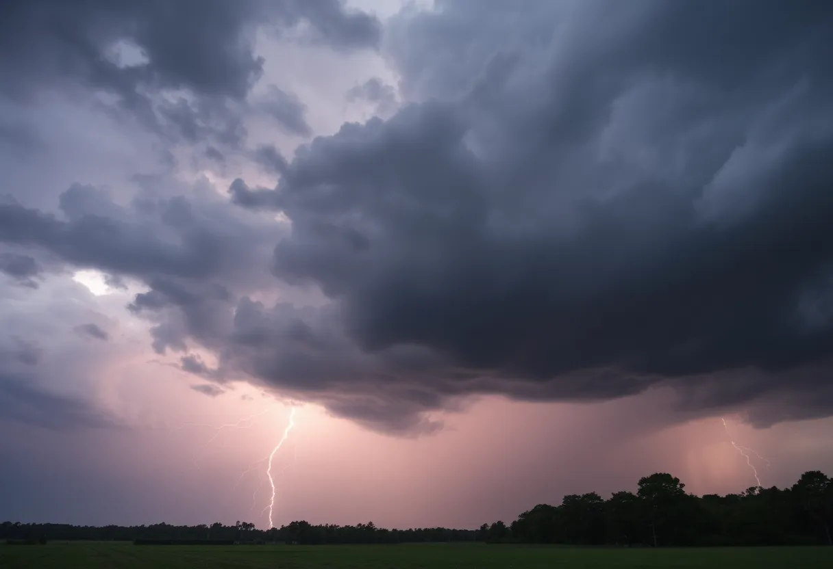
If you happen to be outdoors when the storms roll in, do yourself a favor and find a safe spot inside! This storm is not just a little rain shower—it’s bringing frequent cloud-to-ground lightning and torrential rain that could lead to localized flooding. Remember, you shouldn’t drive through flooded roadways. Your safety is the priority!
Lightning Risks
Those flashes of lightning might look cool from afar, but don’t let it fool you! Lightning can strike up to 10 miles away from the storm. And to give you an idea, about 25 million lightning strikes occur in the U.S. each year, mostly in the summer months. So, when you hear that thunder rumbling, take it seriously! The average storm can really up your risk for those zap-inducing strikes!
Hydroplaning – An Often Overlooked Danger
Speaking of driving, let’s chat about *hydroplaning*. That’s when your vehicle starts to slide uncontrollably on wet roads because of built-up water in front of the tire. It can happen quickly, so be cautious! If there’s water pooling on the roads, keep your distance from cars ahead of you and drive slowly!
Continued Precautions
This alert is not an isolated incident either; it’s part of a larger trend. Other counties such as Clarendon, Kershaw, Lee, and Sumter have been warned too, with watches remaining effective until midnight. The storms are expected to continue through the evening, with damaging winds, possible hail, and localized flooding all on the table.
Stay Updated and Prepared
As cleanup and repairs continue in the wake of previous storms, it’s wise to stay prepared for more severe weather. The National Weather Service has mentioned that there’s a chance of even more intense weather, including the potential for tornadoes in the coming days. So, make sure you have that emergency kit ready and ensure your battery-operated radio is working!
Final Thoughts
As we navigate through these stormy times, let’s make safety our top priority. Stay indoors, keep updated on weather alerts, and when the skies clear, check on your neighbors and loved ones. Remember—a little preparation now can go a long way when dealing with severe weather.
Deeper Dive: News & Info About This Topic
HERE Resources
Severe Thunderstorm and Tornado Alerts Cause Concern in the CSRA
Myrtle Beach Faces Severe Thunderstorm Warnings
Severe Thunderstorm Alert Rocks Charleston Area
Severe Thunderstorm Warning Issued for Orangeburg, Lexington, and Aiken Counties
Severe Thunderstorm Warnings Issued for Upstate South Carolina
Columbia Braces for Severe Thunderstorm Warnings
Severe Thunderstorm Warnings in Upstate South Carolina
Severe Thunderstorm Warnings Issued for South Carolina Counties
Severe Thunderstorm Warnings Sweep South Carolina: Stay Alert!
Severe Thunderstorms Sweep Through South Carolina
Additional Resources
- The State
- Wikipedia: Severe Thunderstorm
- Herald Online
- Google Search: Thunderstorm Safety
- Island Packet
- Google Scholar: Thunderstorm Effects
- Myrtle Beach Online
- Encyclopedia Britannica: Thunderstorm
- WLTX
- Google News: Severe Weather Alerts
Author: STAFF HERE ROCK HILL
The ROCK HILL STAFF WRITER represents the experienced team at HERERockHill.com, your go-to source for actionable local news and information in Rock Hill, York County, and beyond. Specializing in "news you can use," we cover essential topics like product reviews for personal and business needs, local business directories, politics, real estate trends, neighborhood insights, and state news affecting the area—with deep expertise drawn from years of dedicated reporting and strong community input, including local press releases and business updates. We deliver top reporting on high-value events such as the Come-See-Me Festival, Rock Hill Arts Festival, and motorsport events at the Rock Hill Velodrome. Our coverage extends to key organizations like the Rock Hill Chamber of Commerce and the Culture & Heritage Museums, plus leading businesses in manufacturing and technology that power the local economy such as 3D Systems and Comporium. As part of the broader HERE network, including HEREAiken.com, HEREBeaufort.com, HEREChapin.com, HERECharleston.com, HEREClinton.com, HEREColumbia.com, HEREGeorgetown.com, HEREGreenwood.com, HEREGreenville.com, HEREHiltonHead.com, HEREIrmo.com, HEREMyrtleBeach.com, HERENewberry.com, HERERockHill.com, and HERESpartanburg.com, we provide comprehensive, credible insights into South Carolina's dynamic landscape.


