News Summary
Charleston is preparing for severe thunderstorms as the National Weather Service issues warnings for several counties. Residents should be cautious of potential hail, gusty winds, and hydroplaning risks as a storm system approaches. The threat extends to West Virginia and includes warnings for high winds and possible flash flooding. Locals are advised to stay informed via local weather updates and maintain safety precautions during the stormy conditions.
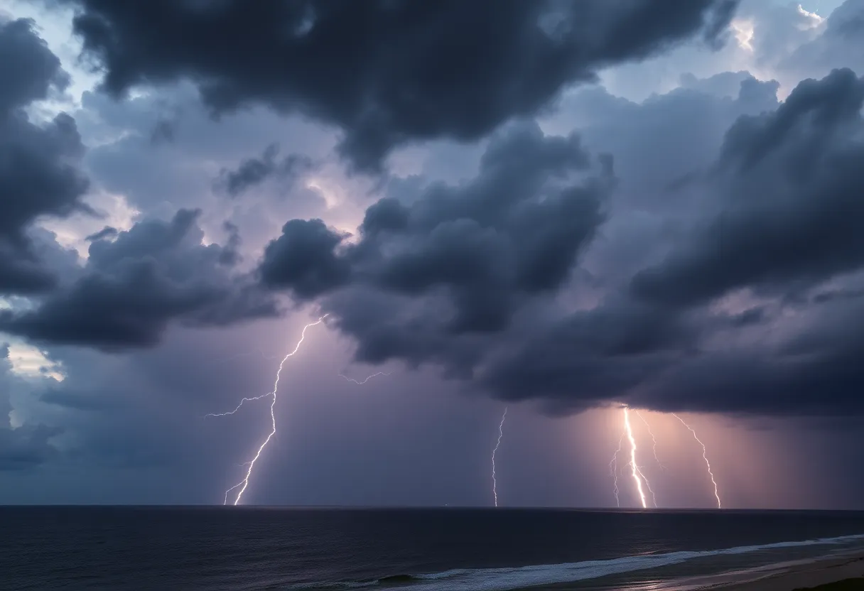
Severe Thunderstorm Warnings Roll into Charleston as Storm System Approaches
Charleston is bracing for *wild weather* as the National Weather Service (NWS) has issued a severe thunderstorm warning that began early in the morning on Monday. The alert, which was rolled out at 1:41 a.m., is expected to last until 2:30 a.m. and is aimed specifically at Coastal Colleton, Beaufort, and Charleston counties. Residents are advised to keep their eyes peeled, as the storm could bring more than just a heavy downpour.
What to Expect from the Storm
The NWS is forecasting storms that could pack quite a punch, with *penny-sized hail*—or hail measuring up to 0.75 inches in size. If you’re in areas like Edisto Beach, Edisto Island, Edisto Beach State Park, Harbor Island, or Hunting Island, you should be ready for these conditions. Doppler radar has already spotted a strong thunderstorm near Fripp Island, moving northeast at a brisk pace of 15 mph. The potential for *gusty winds* suggests that there may be tree limb damage and the risk of unsecured items being blown around.
Remember, if lightning is your enemy during a storm, you’re not alone! Around 25 million lightning strikes hit the United States annually, with *most occurring in the summer months*. Sadly, approximately 20 lives are lost each year due to lightning strikes, making it all the more important to stay safe when storms are in the forecast.
Driving Warnings and Safety Precautions
As the rain falls and streets become slick, the risk of *hydroplaning* rises. This dangerous situation happens when a vehicle succumbs to *poor road traction* caused by water buildup. Always keep in mind the three main causes of hydroplaning: water accumulation in front of the tire, inadequate tire tread depth, and high vehicle speed. So, it’s best to slow down and maintain caution on wet roads!
West Virginia Weather on the Same Day
Charleston has a severe thunderstorm watch in place until 9 p.m., while Georgetown and Williamsburg Counties have until 10 p.m. to be on guard. As this *cold front* sweeps through, it could raise wind gusts to dangerous levels, particularly for high-profile vehicles on bridges. The Storm Prediction Center rated the storm threat for inland South Carolina at three on a five-level scale, meaning caution is necessary.
What Can We Do?
Folk in Charleston and surrounding areas should stay glued to their local weather updates and the NOAA Weather Radio All Hazards for the latest news on storm developments. And while we’re keeping our umbrellas at the ready, we shouldn’t overlook ongoing concerns of wildfire risks throughout South Carolina. The Keetch–Byram Drought Index, which measures potential wildfire danger, indicates that even with incoming storms, conditions might still not be sufficient to reduce fire threats completely.
The Day After
As for the forecast beyond this stormy Monday? Expect dense fog and more thunderstorms to roll in after 2 p.m. on Tuesday, adding another layer of unpredictability to the week ahead. So, Charleston, take care out there! Keep your loved ones close, your weather apps open, and be prepared for whatever Mother Nature decides to throw your way!
Deeper Dive: News & Info About This Topic
HERE Resources
Severe Thunderstorm Warnings Across South Carolina and Arkansas
Myrtle Beach on Alert: Strong Thunderstorms Bring Hail and High Winds
Severe Thunderstorm and Flood Watch for Upstate South Carolina
Severe Thunderstorms and Winds Hit Mecklenburg County
Severe Thunderstorm Alert Issued for Spartanburg County
Severe Thunderstorm Warning Issued for South Carolina
Rock Hill Weather Forecast: Warm Days and Thunderstorms Ahead
Unseasonably Warm Weather and Storm Chances for Rock Hill
Severe Thunderstorm Warnings Hit Georgetown: What You Need to Know!
Severe Thunderstorm Warning in South Carolina: Stay Prepared!
Additional Resources
- West Virginia Gazette
- Live 5 News
- Island Packet
- WYFF 4
- Grice Connect
- Wikipedia: Thunderstorm
- Google Search: Severe Thunderstorm Warnings
- Google Scholar: Thunderstorm Precautions
- Encyclopedia Britannica: Thunderstorm
- Google News: Thunderstorm Alert
Author: STAFF HERE ROCK HILL
The ROCK HILL STAFF WRITER represents the experienced team at HERERockHill.com, your go-to source for actionable local news and information in Rock Hill, York County, and beyond. Specializing in "news you can use," we cover essential topics like product reviews for personal and business needs, local business directories, politics, real estate trends, neighborhood insights, and state news affecting the area—with deep expertise drawn from years of dedicated reporting and strong community input, including local press releases and business updates. We deliver top reporting on high-value events such as the Come-See-Me Festival, Rock Hill Arts Festival, and motorsport events at the Rock Hill Velodrome. Our coverage extends to key organizations like the Rock Hill Chamber of Commerce and the Culture & Heritage Museums, plus leading businesses in manufacturing and technology that power the local economy such as 3D Systems and Comporium. As part of the broader HERE network, including HEREAiken.com, HEREBeaufort.com, HEREChapin.com, HERECharleston.com, HEREClinton.com, HEREColumbia.com, HEREGeorgetown.com, HEREGreenwood.com, HEREGreenville.com, HEREHiltonHead.com, HEREIrmo.com, HEREMyrtleBeach.com, HERENewberry.com, HERERockHill.com, and HERESpartanburg.com, we provide comprehensive, credible insights into South Carolina's dynamic landscape.

