News Summary
Residents in South Carolina, particularly in Charleston and surrounding areas, are under a severe thunderstorm warning. Strong thunderstorms, with winds reaching up to 60 mph and penny-sized hail, are expected. Safety measures include staying indoors and securing outdoor items. The storms are forecasted to affect multiple counties until late evening. Stay updated through local channels and exercise caution if driving during these conditions.
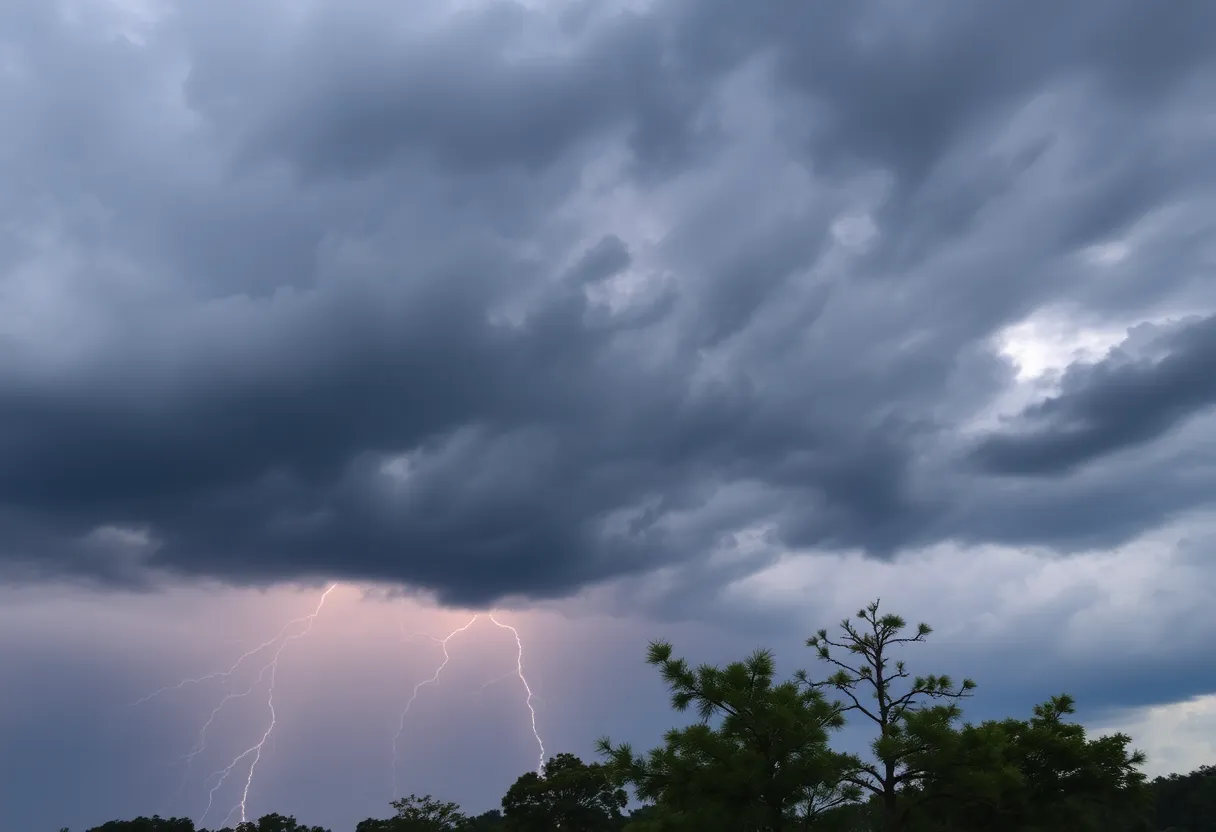
Severe Thunderstorm Warning in South Carolina: Stay Prepared!
As the sun set over Charleston on Saturday, an urgent weather alert was issued by the National Weather Service (NWS). At 6:43 p.m., residents were warned about strong thunderstorms expected to sweep through multiple counties, particularly Inland Berkeley, until 7:15 p.m. Brace yourselves, folks, because these storms are no joke!
What to Expect
Picture this: strong thunderstorms rolling in, accompanied by penny-sized hail (about 0.75 inches). If you’re wondering how significant that might be, just imagine small balls of ice plummeting from the sky! 🚨 Doppler radar has already spotted a formidable storm brewing just six miles southeast of Saint Stephen, moving southeast at about 20 miles per hour. If you reside in areas like Bonneau, Jamestown, Bonneau Beach, Northern Lake Moultrie, or anywhere in the vicinity, it’s time to pay attention!
The winds accompanying these thunderstorms could reach up to 60 mph, enough to potentially knock down tree limbs and toss around unsecured outdoor items. Minor damage to yards and decks is a possibility—so if you have anything lightweight lying around, you might want to secure it quickly!
Safety Measures
The NWS strongly recommends that everyone stay tuned to local radio and television channels for real-time updates and any additional warnings. If you’re out enjoying the beautiful landscapes near Lake Moultrie, be sure to move indoors or get inside a vehicle. Lightning can strike surprisingly far from the storm—up to 10 miles away, in fact! It’s better to be safe than sorry, given that the U.S. experiences around 25 million lightning strikes each year, resulting in about 20 fatalities annually.
The Storm’s Journey
As of 7:02 p.m., the radar showed severe thunderstorms stretching from near Hampton Plantation State Park to well over the Isle of Palms, traveling southeast at a brisk 45 mph. Just imagine the force of nature as strong gusts push through your neighborhood!
The storm threat for South Carolina’s inland areas is rated at a level 3 out of a maximum of 5. This indicates a significant risk associated with thunderstorms. While it appears that the storm will begin to weaken before hitting the coast, the hazards of strong winds and small hail remain a concern.
Driving Precautions
Part of the weather tip sheet includes advice on driving during such storms. Hydroplaning can occur when vehicles slide uncontrollably over wet roads caused by excessive water. It’s no surprise that high speeds and worn-out tires play a significant role in hydroplaning incidents. If you find yourself on the road tonight, consider slowing down and exercising caution to maintain control.
Severe Thunderstorm Watch Continues
Don’t forget, the severe thunderstorm watch is in place until 9 p.m. for Charleston County and stretches until 10 p.m. for counties such as Georgetown and Williamsburg. Staying vigilant is essential, as parts of the area could even witness hail up to one inch in diameter!
In summary, it’s a weather event to watch closely. Stay indoors, keep your pets safe, and make sure any outdoor belongings are secure. And as they say, better safe than sorry, right? When the skies unleash their fury, being prepared could make the difference. So, keep an eye out, stay informed, and most importantly, stay safe!
Deeper Dive: News & Info About This Topic
HERE Resources
Weather Alert Issued for Thunderstorms in Upstate South Carolina
Severe Thunderstorm Alert Issued for Midlands, SC
Thunderstorms Expected in Abbeville, Laurens, and Greenwood Counties
Strong Thunderstorm Warning Issued for Local Counties
Severe Thunderstorms Cause Widespread Damage in Chester County
Severe Thunderstorm Warning for Laurens, Union, and Chester Counties
South Carolinians Brace for Weather Shift as Cold Front Approaches
Tragedy Strikes in Lancaster County
High School Football Teams Gear Up for 2025 Keep Pounding Classic
York County Faces Severe Thunderstorm Warning
Additional Resources
- Live 5 News: Severe Thunderstorm Warnings
- Wikipedia: Severe Thunderstorm
- WYFF4: Severe Weather Timing
- Google Search: Severe Weather in South Carolina
- Count On 2: Severe Storms Likely
- Google Scholar: Severe Thunderstorm Impact
- The Weather Channel: Severe Weather Video
- Encyclopedia Britannica: Thunderstorm
- WV Metro News: Storms Pack a Punch
Author: STAFF HERE ROCK HILL
The ROCK HILL STAFF WRITER represents the experienced team at HERERockHill.com, your go-to source for actionable local news and information in Rock Hill, York County, and beyond. Specializing in "news you can use," we cover essential topics like product reviews for personal and business needs, local business directories, politics, real estate trends, neighborhood insights, and state news affecting the area—with deep expertise drawn from years of dedicated reporting and strong community input, including local press releases and business updates. We deliver top reporting on high-value events such as the Come-See-Me Festival, Rock Hill Arts Festival, and motorsport events at the Rock Hill Velodrome. Our coverage extends to key organizations like the Rock Hill Chamber of Commerce and the Culture & Heritage Museums, plus leading businesses in manufacturing and technology that power the local economy such as 3D Systems and Comporium. As part of the broader HERE network, including HEREAiken.com, HEREBeaufort.com, HEREChapin.com, HERECharleston.com, HEREClinton.com, HEREColumbia.com, HEREGeorgetown.com, HEREGreenwood.com, HEREGreenville.com, HEREHiltonHead.com, HEREIrmo.com, HEREMyrtleBeach.com, HERENewberry.com, HERERockHill.com, and HERESpartanburg.com, we provide comprehensive, credible insights into South Carolina's dynamic landscape.


