News Summary
Florence, Marion, and Williamsburg counties in South Carolina are under a severe thunderstorm watch. The National Weather Service warned of strong winds, heavy rain, and potential flooding, urging residents to prepare for hazardous conditions. With gusts reaching 40 mph and rainfall amounts forecasted between two to four inches, local authorities have implemented emergency measures, including a curfew and the opening of emergency shelters. Residents are advised to avoid unnecessary travel and stay indoors to ensure their safety as the storm unfolds.
Severe Thunderstorm Watch Sparks Caution in Florence, Marion, and Williamsburg Counties
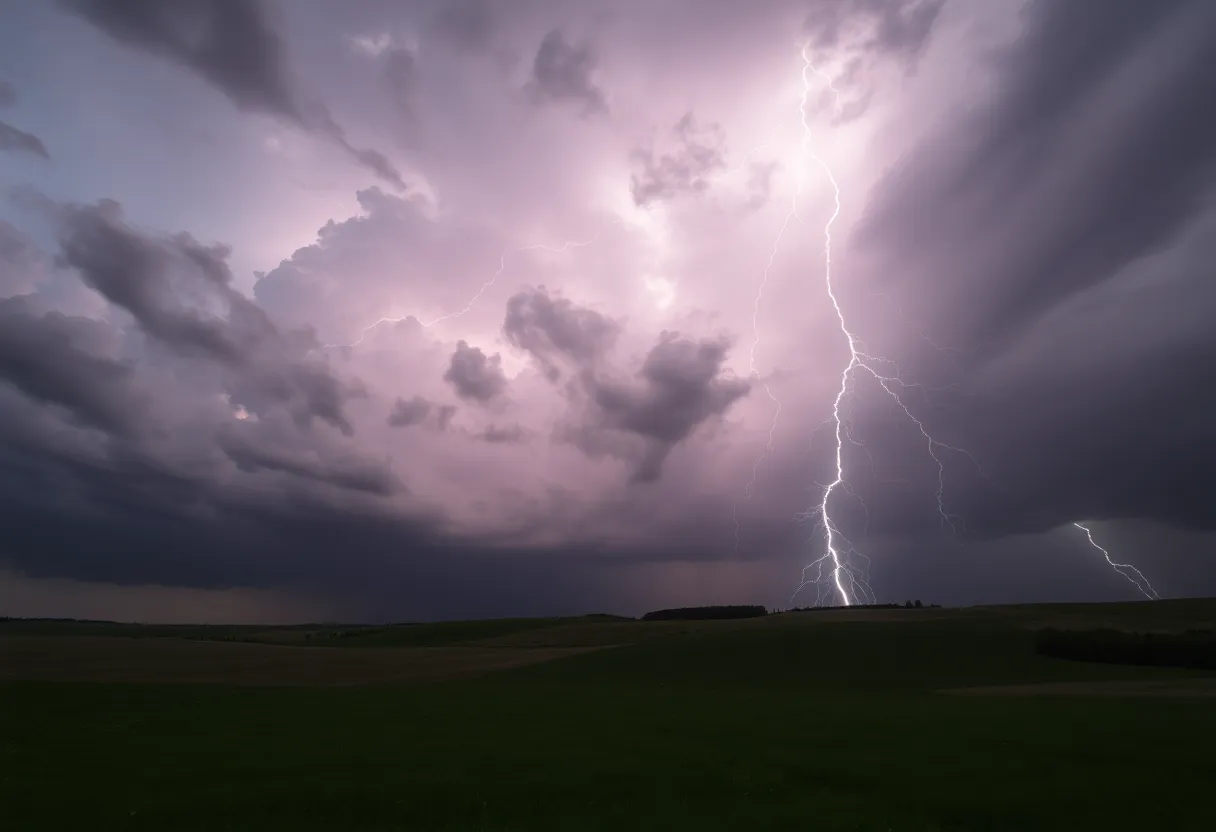
Florence, South Carolina is bracing itself for a *weather spectacle* as the National Weather Service (NWS) Wilmington NC dropped a thunderstorm warning just after 7 PM on Thursday. The alert, keeping an eye on those in Florence, Marion, and Williamsburg counties, warns residents to be prepared for strong thunderstorms until about 7:45 PM. The skies are certainly looking dramatic!
Residents in these regions should keep their *window blinds down* and their umbrellas handy because wind gusts could soar to *40 mph*. That’s enough force to send those lightweight patio chairs flying across the yard! The latest updates from Doppler radar show ominous storm activity stretching from Timmonsville to near Friendfield and Kingstree, moving northeast at a brisk 45 mph. If you’re in Florence, Lake City, or Kingstree, you might want to consider seeking shelter. Secure windows and doors, and grab a cozy blanket as the storm breathes down on our community.
The Where and What of the Thunderstorm
As the thunder cracks and the winds howl, various locations across Florence County are set to feel the storm’s wrath. Areas like Timmonsville, Johnsonville, Pamplico, Quinby, Blue Brick, Mars Bluff, and many more should be prepared. Plus, if you’re hitting the highways tonight, keep an eye out—Interstate 20 near mile marker 141 and Interstate 95 between mile markers 151 and 163 could see some rough patches due to the weather.
The storm initially started to brew at around 6:35 PM, with *gusty winds*, rattling nerves and trees alike. Pea-sized hail and electrical fireworks in the sky (yes, we mean lightning!) added to the *intensity of the night*. As the clock struck 7:45 PM, the storm showed no signs of moving on, and along with it came the worry of heavy rainfall.
Heavy Rainfall and a Flood Advisory
Fast forward to 8:09 PM, and the NWS issues a flood advisory. Reports indicate that *two to four inches of rain* had soaked the ground, with an additional one to three inches looking likely. Resident reports from near Effingham even shared details of rainfall amounts topping out at a jaw-dropping *8.25 inches*! Elim community wasn’t far behind with *7.34 inches*. That is a lot of moisture!
Keeping safety at the forefront, emergency measures are already underway in Florence County. Officials have initiated a *curfew* from sundown to sunrise to discourage unnecessary travel following the declaration of a state of emergency. Local authorities are asking folks to avoid flooded roads, particularly those in Florence, Lake City, and Timmonsville. Safety comes first, after all!
Preparing for potential flooding
More precautions are being taken. Residents can access sandbags on a first-come-first-serve basis—better safe than soggy! Emergency shelters are now open at *Lake City High School* and *South Florence Freshman Academy*, ensuring that everyone has a place to stay safe during this tumultuous weather.
In response to the storm’s potential disruptions, Francis Marion University has decided to shift gears, transitioning to virtual instruction starting August 6. School districts in the Pee Dee area are not taking it lightly either, with events rescheduled and eLearning days slated for August 7 and 8. Plus, on those days, government offices across Florence County will be closed, though some city services may continue, weather permitting.
As we watch the storm unfold in Florence and surrounding areas, let’s remember to stay safe, stay connected, and—most importantly—stay indoors as much as possible. Keep those flashlights close and your spirits high while Mother Nature reminds us of her *wild side*!
Deeper Dive: News & Info About This Topic
HERE Resources
Floyd, New Mexico: EF-1 Tornado Brings Damage and Disruption
Severe Thunderstorms Hit Lowcountry of South Carolina
Severe Weather Alert: Thunderstorms Hit South Carolina and North Carolina
Severe Thunderstorms and Flooding Warnings Hit Charleston
Severe Thunderstorms Alert for Coastal South Carolina
York County, SC Experiences Dramatic Supercell Thunderstorm
Severe Thunderstorm Warnings Issued for York and Chester Counties
Severe Thunderstorm Warning for Bamberg and Orangeburg Counties, SC
Brush Fires Prompt Evacuations in North and South Carolina
Severe Thunderstorm Alert for Rowan and Cabarrus Counties
Additional Resources
- WAFF: Traffic Light Down in Florence Following Severe Weekend Storms
- Wikipedia: Thunderstorm
- AL.com: Thunderstorms with Quarter-Sized Hail and Damaging Winds in Northwest Alabama
- Google Search: Severe Thunderstorm Watch
- WAFF: Possible Tornado Reported in Florence
- Encyclopedia Britannica: Flood
- Post and Courier: Tropical Storm Debbie Weather Flooding Update
- Google News: Tropical Storm Debbie
Author: STAFF HERE ROCK HILL
The ROCK HILL STAFF WRITER represents the experienced team at HERERockHill.com, your go-to source for actionable local news and information in Rock Hill, York County, and beyond. Specializing in "news you can use," we cover essential topics like product reviews for personal and business needs, local business directories, politics, real estate trends, neighborhood insights, and state news affecting the area—with deep expertise drawn from years of dedicated reporting and strong community input, including local press releases and business updates. We deliver top reporting on high-value events such as the Come-See-Me Festival, Rock Hill Arts Festival, and motorsport events at the Rock Hill Velodrome. Our coverage extends to key organizations like the Rock Hill Chamber of Commerce and the Culture & Heritage Museums, plus leading businesses in manufacturing and technology that power the local economy such as 3D Systems and Comporium. As part of the broader HERE network, including HEREAiken.com, HEREBeaufort.com, HEREChapin.com, HERECharleston.com, HEREClinton.com, HEREColumbia.com, HEREGeorgetown.com, HEREGreenwood.com, HEREGreenville.com, HEREHiltonHead.com, HEREIrmo.com, HEREMyrtleBeach.com, HERENewberry.com, HERERockHill.com, and HERESpartanburg.com, we provide comprehensive, credible insights into South Carolina's dynamic landscape.


