News Summary
Residents in Upstate South Carolina should prepare for severe thunderstorms as the National Weather Service has issued a warning for the area. Expected conditions include marble-sized hail and strong winds, potentially reaching 50 mph. Key areas affected include Anderson County, Seneca, and Spartanburg. A Severe Thunderstorm Watch is in effect, urging residents to seek shelter and stay alert for hazardous lightning and wind gusts that could lead to significant damage.
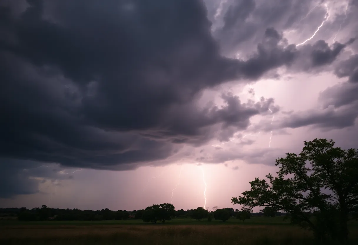
Severe Thunderstorms Brewing in Upstate South Carolina
Residents of Upstate South Carolina, brace yourselves! The National Weather Service (NWS) has issued an alert for some serious thunderstorms that are making their way through the area. At 7:35 a.m. on Saturday, a warning was released that extends until 8 a.m., specifically affecting Greater Oconee, Greater Pickens, and Anderson County.
What to Expect
So, what can you expect from these storms? The thunderstorms may bring along with them marble-sized hail—that’s about half an inch—and fierce winds with gusts reaching up to 50 mph. Yikes! Doppler radar has already picked up a strong thunderstorm located just seven miles south of Seneca, and it’s moving at quite the pace—around 45 mph eastward.
Such gusty wind could easily knock down tree limbs and send unsecured items flying across your yard, while minor hail damage to outdoor decorations or furniture is also a possibility. The locations likely to be affected include Townville, Sandy Springs, Seneca, Pendleton, Williamston, West Pelzer, Homeland Park, Anderson Airport, Broadway Lake, and, of course, Anderson itself. If you happen to be outdoors, it’s wise to find shelter inside a sturdy building.
Keep Your Eyes on the Skies
A Severe Thunderstorm Watch remains in effect until noon, so stay alert, everyone! When thunderstorms are nearby, the risk of lightning strikes dramatically ramps up. Did you know that around 25 million strikes occur each year in the U.S., particularly during summer months? On average, they lead to approximately 20 fatalities annually. The closer the storm gets, the higher the chances of being struck, peaking right when it’s overhead.
Before the day started, a severe thunderstorm warning was already in effect for Cherokee and Spartanburg counties, until 7 a.m. This particular storm was spotted about 12 miles northwest of Spartanburg near Lake Bowen and was traveling east at 40 mph. Locally, residents can expect wind gusts up to 60 mph and even quarter-sized hail—think about an entire inch! Damages such as hail hitting vehicles and wind snapping trees and power lines are anticipated.
Stay Safe Out There!
If you reside in Cliffside, Cowpens National Battlefield, Lake Bowen, Chesnee, Harris, Spartanburg, Inman, Mayo, USC Upstate, or Green Creek, now is the time to head for cover! The best bet is to find an interior room on the lowest floor of your home to keep safe during the storm.
As we look ahead to May 8, it seems the storm threat is escalating—a level two severe storm warning is on the horizon with an 80% chance of showers and thunderstorms in the afternoon. Expect some fierce wind gusts that could hit 58 mph or more, along with hail diameter predictions ranging from one inch to a quarter of an inch north of I-85. Thunderstorm activity could occur between 6 p.m. and midnight, making for a wild evening.
Weather Watch Continues
The atmosphere is showing signs of instability, backed by an upper disturbance that is brewing potential severe weather conditions. Rain and thunderstorm chances appear to carry through into the night but decrease slightly with a 40% chance of showers.
Fast forward to May 9, when scattered showers and isolated thunderstorms are expected with a 50% chance of rain. However, thankfully, the likelihood of hail will be on the lower side compared to the days before. As we move toward May 10, the region should expect drier conditions with minimal precipitation chances hovering around 30%.
And don’t get too comfortable just yet! A slight change in the weather pattern is expected for May 11 with rain chances rising again up to 40%. So, stay tuned, stay safe, and keep your umbrellas handy!
Deeper Dive: News & Info About This Topic
HERE Resources
Severe Weather Alerts Issued for Columbia Residents
Tragedy Strikes Southern Kentucky: Tornado Claims Lives and Damages Communities
Severe Weather Disrupts Carolinas and Georgia
Severe Thunderstorm Alert Shakes Up Chesterfield County
Severe Thunderstorm Warnings in South Carolina and Georgia
Heavy Rain and Flooding Ahead: Prepare for an Atmospheric River!
Thunderstorm Warnings Light Up Lowcountry Night Sky
Severe Thunderstorm Warning Hits Chester County
Severe Thunderstorm Alert Issued for York County
Thunderstorm Alert Hits Beaufort and Jasper Counties!
Additional Resources
- The State
- Wikipedia: Thunderstorm
- Island Packet
- Google Search: severe thunderstorm alerts South Carolina
- Greenville Online
- Google Scholar: severe weather impact South Carolina
- Myrtle Beach Online
- Encyclopedia Britannica: Lightning
- WSPA
- Google News: thunderstorm warning South Carolina
- Island Packet
- Encyclopedia Britannica: Severe Thunderstorm
Author: STAFF HERE ROCK HILL
The ROCK HILL STAFF WRITER represents the experienced team at HERERockHill.com, your go-to source for actionable local news and information in Rock Hill, York County, and beyond. Specializing in "news you can use," we cover essential topics like product reviews for personal and business needs, local business directories, politics, real estate trends, neighborhood insights, and state news affecting the area—with deep expertise drawn from years of dedicated reporting and strong community input, including local press releases and business updates. We deliver top reporting on high-value events such as the Come-See-Me Festival, Rock Hill Arts Festival, and motorsport events at the Rock Hill Velodrome. Our coverage extends to key organizations like the Rock Hill Chamber of Commerce and the Culture & Heritage Museums, plus leading businesses in manufacturing and technology that power the local economy such as 3D Systems and Comporium. As part of the broader HERE network, including HEREAiken.com, HEREBeaufort.com, HEREChapin.com, HERECharleston.com, HEREClinton.com, HEREColumbia.com, HEREGeorgetown.com, HEREGreenwood.com, HEREGreenville.com, HEREHiltonHead.com, HEREIrmo.com, HEREMyrtleBeach.com, HERENewberry.com, HERERockHill.com, and HERESpartanburg.com, we provide comprehensive, credible insights into South Carolina's dynamic landscape.


