News Summary
Columbia, South Carolina, is currently facing severe weather conditions, including strong thunderstorms, damaging wind gusts, and power outages. With wind speeds reaching up to 60 mph, residents are advised to stay indoors and avoid flooded roadways. Local authorities are on high alert, responding to downed power lines and structure fires. The weekend forecast indicates more severe storms, raising concerns about possible tornadoes and additional damage. Residents are encouraged to prepare by securing their properties and stocking emergency kits.
Severe Weather Wreaks Havoc in Columbia, South Carolina
Oh boy, Columbia is feeling the effects of some fierce weather as strong thunderstorms have rolled into the area, leaving a trail of damage and power outages in their wake. On Friday night, just as the clock approached 8:11 p.m., the National Weather Service issued an updated weather alert for our beloved Midlands, specifically targeting Richland, Lee, Sumter, and Clarendon counties. The alert warned residents to brace for some serious wind gusts reaching speeds of up to 50 mph!
What’s Happening Out There?
As the thunderstorm activated alarms, Doppler radar pinpointed a particularly menacing storm hovering near Oakland and Shaw Air Base, making its way east at about 20 mph. Residents were advised to stay indoors, especially if they found themselves outdoors during the storm. Winds this high can easily knock down tree limbs and send unsecured objects crashing. It’s a good time to secure those lawn chairs!
Along with the wind, there’s a chance for torrential rainfall, which could cause localized flooding. If you’re driving, it’s best to avoid flooded roadways at all costs. Remember, rushing water can be deceiving and dangerous!
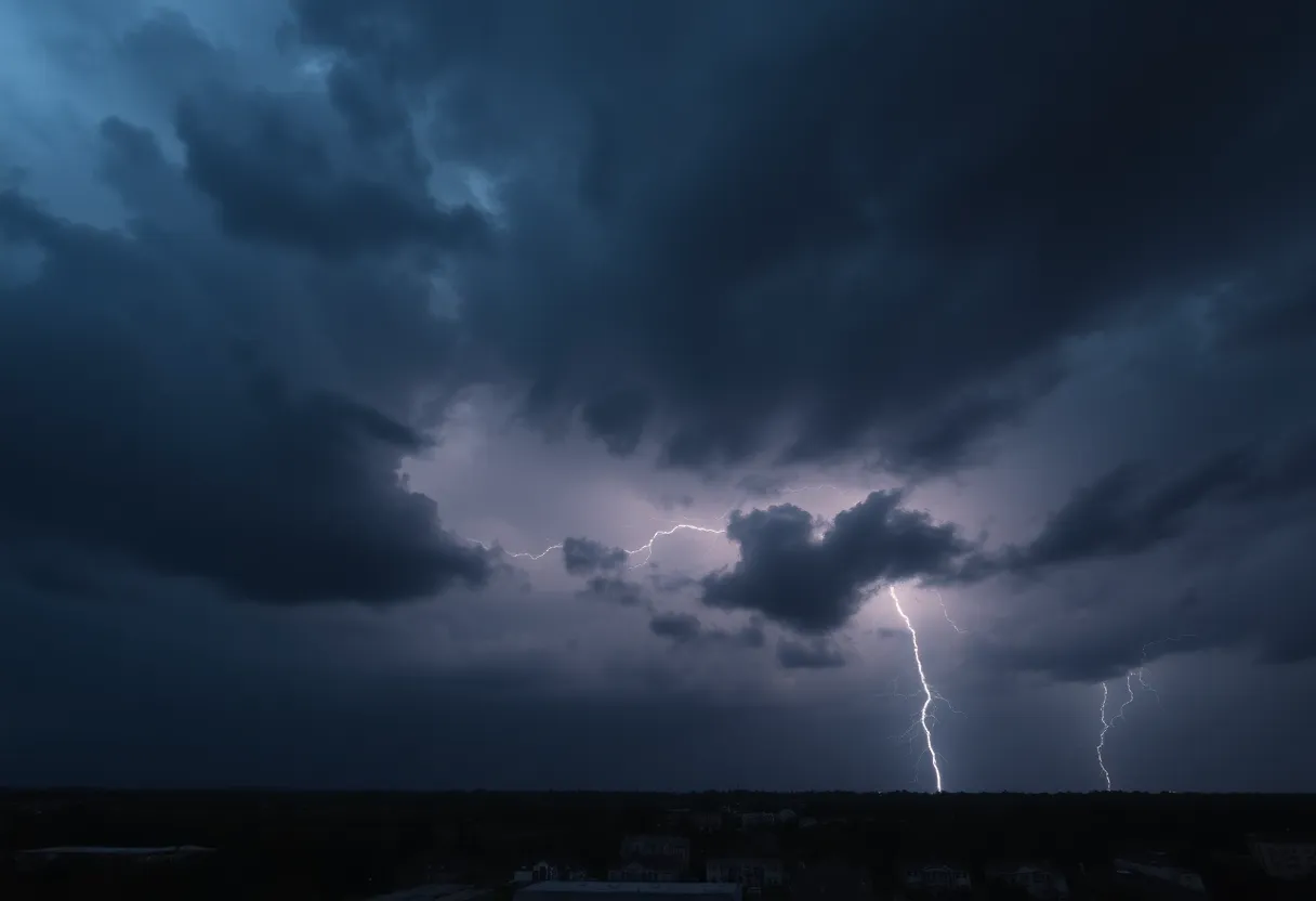
Lightning Warnings
As summer takes center stage, so does the frequency of lightning. On average, the U.S. is struck by lightning around 25 million times a year, with about 20 lives lost to its fury annually. The chance of encountering a lightning strike peaks as thunderstorms approach, further emphasizing the importance of finding safe shelter.
Looking Ahead
On Sunday morning at 10:40 a.m., the storm warnings continued to roll in, this time extending to Columbia, Lexington, and West Columbia, predicting wind gusts even higher at 60 mph and the possibility of hail. Saturday’s storms had already wreaked havoc, with wind gusts of up to 60 mph causing significant damage across the Midlands. Around 10,000 customers were left without power as the intensity of the winds took out trees and power lines alike.
Sunday’s Outlook
The weekend isn’t looking any sunnier, with severe weather set to rage on from 10 a.m. to 4 p.m. on Sunday. The area south of the Interstate 20 corridor is expected to bear the brunt of this storm, prompting officials to warn boaters on Lake Murray to find safe harbor.
Moreover, if you live in counties like Saluda, Edgefield, or McCormick, you’ll want to pay close attention! The forecast shows a significant chance of thunderstorms with total precipitation likely exceeding 40% in some areas. Locally, you could see even more rain during the heavier storm bursts.
What About Monday?
If you thought Sunday was rough, Monday follows with more expected severe weather, including the unsettling possibility of tornadoes and damaging winds. Residents should prepare for multiple waves of strong storms, potentially leading to further significant damage. By Monday night, expect to see totals of up to an inch of rain, which certainly has us all thinking about those umbrellas!
Power Outages and Cleanup Efforts
As of Sunday evening, power outages were still plaguing the Columbia area, affecting around 2,400 customers. In addition, roads in Cole County were reported closed due to flooding, making travel challenging.
The Sedalia Fire Department has been inundated with calls, responding to numerous structure fires and downed power lines caused by the relentless weather. Local authorities continue to keep a close eye on the situation, urging everyone to stay away from downed lines and any flooded areas.
What Can You Do?
As this unpredictable weather system hangs over us, it’s essential to stay safe and monitor updates closely. Make sure your emergency kit is stocked, and check in on loved ones, especially the elderly and those who may not have access to information. Stay safe out there, Columbia!
Deeper Dive: News & Info About This Topic
HERE Resources
Winter Weather Advisory Issued for Columbia, South Carolina
Anderson, South Carolina Faces Severe Thunderstorm Warning
Severe Thunderstorm Alerts Issued for South Carolina
Columbia Prepares for Potential Winter Weather
Severe Thunderstorm and Tornado Alerts Cause Concern in the CSRA
Myrtle Beach Faces Severe Thunderstorm Warnings
Severe Thunderstorm Alert Rocks Charleston Area
Severe Thunderstorm Warning Issued for Orangeburg, Lexington, and Aiken Counties
Severe Thunderstorm Warnings Issued for Upstate South Carolina
Columbia Braces for Severe Thunderstorm Warnings
Additional Resources
- The State
- Wikipedia: Thunderstorm
- SI Live
- Google Search: Thunderstorms News
- KOMU
- Encyclopedia Britannica: Thunderstorm
- ABC Columbia
- Google News: Columbia Power Outages
Author: STAFF HERE ROCK HILL
The ROCK HILL STAFF WRITER represents the experienced team at HERERockHill.com, your go-to source for actionable local news and information in Rock Hill, York County, and beyond. Specializing in "news you can use," we cover essential topics like product reviews for personal and business needs, local business directories, politics, real estate trends, neighborhood insights, and state news affecting the area—with deep expertise drawn from years of dedicated reporting and strong community input, including local press releases and business updates. We deliver top reporting on high-value events such as the Come-See-Me Festival, Rock Hill Arts Festival, and motorsport events at the Rock Hill Velodrome. Our coverage extends to key organizations like the Rock Hill Chamber of Commerce and the Culture & Heritage Museums, plus leading businesses in manufacturing and technology that power the local economy such as 3D Systems and Comporium. As part of the broader HERE network, including HEREAiken.com, HEREBeaufort.com, HEREChapin.com, HERECharleston.com, HEREClinton.com, HEREColumbia.com, HEREGeorgetown.com, HEREGreenwood.com, HEREGreenville.com, HEREHiltonHead.com, HEREIrmo.com, HEREMyrtleBeach.com, HERENewberry.com, HERERockHill.com, and HERESpartanburg.com, we provide comprehensive, credible insights into South Carolina's dynamic landscape.


