News Summary
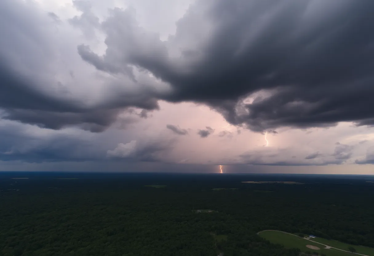
Residents in South Carolina and Georgia are warned to brace for strong thunderstorms this evening, with wind gusts up to 55 mph and potential localized flooding. The National Weather Service has issued a warning that lasts until 11 PM tonight, affecting several counties and key highways. Precautions are important as frequent lightning and heavy rainfall will pose serious risks. Stay indoors and avoid traveling unless necessary.
Strong Thunderstorm Warning in Effect for South Carolina and Georgia
Attention residents of South Carolina and Georgia! Brace yourselves, because strong thunderstorms are rolling in this evening. The National Weather Service (NWS) in Columbia, SC, issued an urgent warning at 9:59 PM that will last until 11 PM tonight. This storm isn’t just a little drizzle; it comes with some serious **wild weather**!
What You Need to Know
The warning covers parts of McCormick, Edgefield, Aiken, and Barnwell counties, so if you’re living in or near these areas, it’s time to take precautions! Be prepared for wind gusts reaching up to **55 mph**. Yes, you read that right. Hold onto your hats, folks, because things could get blustery!
Doppler radar has been tracking these storms, and as of the latest report, they’ve formed a **solid line** extending from about 6 miles north of Wrightsboro down to the vicinity of J. Strom Thurmond Dam and Citizens Park. These thunderstorms are moving southwest at a speed of approximately **15 mph**. If you see dark clouds rolling in, that’s definitely a sign to pay attention!
Areas Likely to be Affected
Are you in or near any of the following locations? If so, you’ll want to stay alert:
- Aiken
- North Augusta
- Grovetown
- Evans
- Thomson
- Fort Eisenhower
- Augusta
- Clearwater
- Martinez
- Aiken Mall
- Belvedere
- Hephzibah
- Harlem
- New Ellenton
- Jackson
- Glendale
- South Augusta
- Clarks Hill Recreation Area
- Mistletoe State Park
- Summerville
Furthermore, if you’re hitting the road, be cautious on these highways, as they could be seriously impacted:
- Interstate 20 in Georgia between mile markers **166 and 201**.
- Interstate 20 in South Carolina between mile markers **0 and 20**.
- Interstate 520 in Georgia between mile markers **1 and 15**.
- Interstate 520 in South Carolina between mile markers **16 and 23**.
Precautions to Take
If you’re outside, the safest place to be is indoors. Take shelter in a sturdy building and avoid any outdoor activities. The storm isn’t just packing wind—it’s also bringing **torrential rainfall**, leading to potential localized flooding. Remember, it’s **never safe to drive through flooded roadways**. Stay put until the storm passes!
And let’s not forget about the **lightning**. People often underestimate the dangers of lightning during a thunderstorm. Frequent cloud-to-ground lightning is expected, and it can strike from up to **10 miles away**. In fact, lightning strikes the U.S. around **25 million times** each year! Sadly, this leads to about **20 fatalities** annually, especially during the summer months. Stay indoors to avoid becoming one of those unfortunate statistics!
Driving Safely During the Storm
Furthermore, if you must travel, be aware of **hydroplaning**, a serious hazard that occurs when your vehicle slides uncontrollably on wet roads due to water buildup. Reduce your speed and drive cautiously, keeping a safe distance from other vehicles. The roads can get slippery, and safety should be your number one priority!
As the storm approaches, it’s vital to stay informed and act responsibly. Check updates regularly, and make wise decisions based on the situation. Please take this warning seriously and stay safe!
Deeper Dive: News & Info About This Topic
HERE Resources
Severe Thunderstorms Lead to Widespread Power Outages in Lowcountry
Tragic Motorcycle Accident Claims Life in Rock Hill
Motorcyclist Dies in York County Crash
Rock Hill Motorcyclist Dies in Fatal Crash
Heat Advisory Issued for Greater Oconee and Pickens Counties
Severe Thunderstorm Warnings Hit Charleston, SC
Strong Thunderstorm Alerts Rumble Through Laurens County, SC
Aiken County Faces Severe Weather with Thunderstorms and Tornadoes
Weather Alert: Strong Thunderstorms Hit Spartanburg and Union Counties
Severe Weather Impacts Millions Across the U.S. This Weekend
Additional Resources
- Island Packet: Severe Weather Update
- Wikipedia: Thunderstorm
- Newsweek: Severe Thunderstorm Warning
- Google Search: Severe Weather Safety
- WYFF4: Pop-Up Storms in Greenville
- Google Scholar: Severe Weather Impacts
- WXII12: Flooding in North Carolina
- Encyclopedia Britannica: Severe Thunderstorm
- CBS17: Severe Thunderstorm Watch
- Google News: Severe Thunderstorm Warnings
Author: STAFF HERE ROCK HILL
The ROCK HILL STAFF WRITER represents the experienced team at HERERockHill.com, your go-to source for actionable local news and information in Rock Hill, York County, and beyond. Specializing in "news you can use," we cover essential topics like product reviews for personal and business needs, local business directories, politics, real estate trends, neighborhood insights, and state news affecting the area—with deep expertise drawn from years of dedicated reporting and strong community input, including local press releases and business updates. We deliver top reporting on high-value events such as the Come-See-Me Festival, Rock Hill Arts Festival, and motorsport events at the Rock Hill Velodrome. Our coverage extends to key organizations like the Rock Hill Chamber of Commerce and the Culture & Heritage Museums, plus leading businesses in manufacturing and technology that power the local economy such as 3D Systems and Comporium. As part of the broader HERE network, including HEREAiken.com, HEREBeaufort.com, HEREChapin.com, HERECharleston.com, HEREClinton.com, HEREColumbia.com, HEREGeorgetown.com, HEREGreenwood.com, HEREGreenville.com, HEREHiltonHead.com, HEREIrmo.com, HEREMyrtleBeach.com, HERENewberry.com, HERERockHill.com, and HERESpartanburg.com, we provide comprehensive, credible insights into South Carolina's dynamic landscape.

