News Summary
Residents of the Carolinas should be alert as the National Weather Service has issued severe thunderstorm warnings. High winds, heavy rain, and the possibility of hail and isolated tornadoes are expected. A significant storm is forecasted for the Charlotte Metro area, with wind damage being the primary concern. Stay safe by securing items and seeking shelter indoors during these storms. Community members are encouraged to report any storm damage to local authorities as conditions evolve.
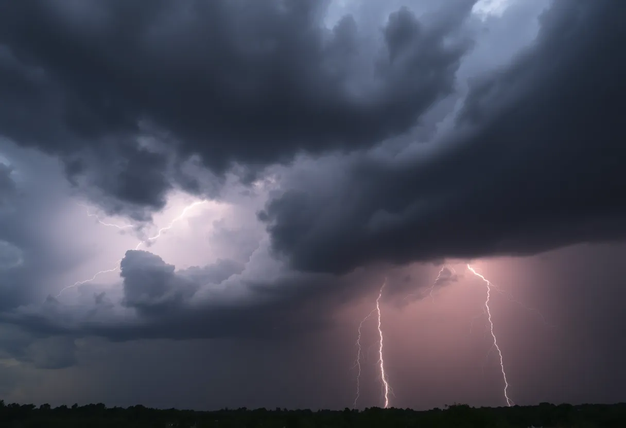
Severe Thunderstorms Threaten the Carolinas!
Attention residents of the Carolinas! The National Weather Service has issued some urgent alerts as strong thunderstorms are moving through the region. As of Friday at 12:30 a.m., reports from Greenville-Spartanburg, SC, indicated that a strong thunderstorm warning was in effect for Laurens and Union counties, lasting until 1:15 a.m. If you live in or around these areas, you’ll want to pay close attention!
What to Expect from the Storms
Weather experts predict wind gusts could reach up to 40 mph as the storms roll through. Doppler radar was tracking thunderstorms stretching from 11 miles northwest of Union to 9 miles east of Laurens, moving east at a brisk pace of 25 mph. If you’re in communities such as Union, Monarch Mill, Buffalo, Jonesville, Carlisle, Rose Hill State Park, Lockhart, Clinton, Tuckertown, or Santuc, prepare yourself, as these storms are headed your way!
Stay Safe During the Storm!
During this turbulent weather, the best advice is to seek shelter indoors if you find yourself outside. Strong winds have the potential to knock down tree limbs and send unsecured items flying. Remember, safety first!
Did you know that the United States experiences about 25 million lightning strikes every year, primarily during the warmer summer months? With each thunderstorm, the likelihood of lightning increases significantly, creating a dangerous situation. Each year, thunderstorms lead to approximately 20 fatalities due to lightning strikes alone. Keep in mind that these risks are higher as the storms approach and decrease as they pass.
Report Storm Damage!
As storms progress, if you experience hail sizes that could be described as penny-sized, or witness damaging winds and downed trees, it’s important to report this information to local authorities. This helps keep the community informed and ensures everyone can respond appropriately. Remember to stay vigilant and safe!
Looking Out for Albany
Meanwhile, in Albany, a severe thunderstorm warning has been issued, with expectations of damaging winds reaching speeds up to 60 mph. The alert is urgent, and the high wind warnings are set to expire by 3:45 p.m. It’s expected that wind speeds in the nearby Schenectady County could hit around 40 mph, with the possibility of heavy rain leading to flash flooding and tricky road conditions.
What’s Happening Across the Carolinas?
Meanwhile, prepare for a wild ride as a Severe Thunderstorm Watch has been announced across several counties in the Carolinas. This watch began at noon on March 31, 2025, and will last until 7 p.m. A big storm is on the way, predicted to impact the Charlotte Metro area during the afternoon and into the early evening hours. Meteorologists are rating these storms as “Level 3” on a scale of 1 to 5 for severe weather risk, meaning you should definitely be on alert!
What’s the Main Threat?
Wind damage is the primary concern, but don’t underestimate the risk of large hail, thunderstorms, and even isolated tornadoes popping up. The best timeline indicates that the storms are expected to make their way to the High Country between noon and 3 p.m. and arrive in the Charlotte area by 2 p.m., lasting until around 6 p.m. The storm systems are expected to move along and east of the Interstate 77 corridor until approximately 9 p.m.
Final Thoughts
So, keep those windows secure, follow updates carefully, and take all necessary precautions to keep yourself and your loved ones safe during this intense weather! Remember, storms can be unpredictable, so staying informed and taking action is key! Let’s weather this storm together!
Deeper Dive: News & Info About This Topic
HERE Resources
Severe Thunderstorms Strike Upstate South Carolina and North Georgia
Tragic Multi-Vehicle Crash Claims Lives in Fort Mill
Tropical Storm Fernand Weakens, No Threat to Bermuda
Massive Haboob Dust Storm Hits Arizona – Visibility Reduced
Weather Alert: Strong Thunderstorms Impacting Conway and Myrtle Beach
Severe Thunderstorm Warnings Affecting South Carolina and California
Thunderstorm Warnings Issued for Upstate South Carolina
Severe Thunderstorm Warning for Henderson County: Prepare Now
Severe Storms Rip Through Pickens County, SC
Severe Weather Alert: Thunderstorms Impact Oconee and Anderson County
Additional Resources
- Greenville Online
- Wikipedia: Thunderstorm
- Times Union
- Google Search: Thunderstorm Safety
- WYFF4
- Google Scholar: Severe Weather Predictions
- Cobb County Courier
- Encyclopedia Britannica: Thunderstorms
- WBTV
- Google News: Severe Thunderstorm Watch
Author: STAFF HERE ROCK HILL
The ROCK HILL STAFF WRITER represents the experienced team at HERERockHill.com, your go-to source for actionable local news and information in Rock Hill, York County, and beyond. Specializing in "news you can use," we cover essential topics like product reviews for personal and business needs, local business directories, politics, real estate trends, neighborhood insights, and state news affecting the area—with deep expertise drawn from years of dedicated reporting and strong community input, including local press releases and business updates. We deliver top reporting on high-value events such as the Come-See-Me Festival, Rock Hill Arts Festival, and motorsport events at the Rock Hill Velodrome. Our coverage extends to key organizations like the Rock Hill Chamber of Commerce and the Culture & Heritage Museums, plus leading businesses in manufacturing and technology that power the local economy such as 3D Systems and Comporium. As part of the broader HERE network, including HEREAiken.com, HEREBeaufort.com, HEREChapin.com, HERECharleston.com, HEREClinton.com, HEREColumbia.com, HEREGeorgetown.com, HEREGreenwood.com, HEREGreenville.com, HEREHiltonHead.com, HEREIrmo.com, HEREMyrtleBeach.com, HERENewberry.com, HERERockHill.com, and HERESpartanburg.com, we provide comprehensive, credible insights into South Carolina's dynamic landscape.

