News Summary
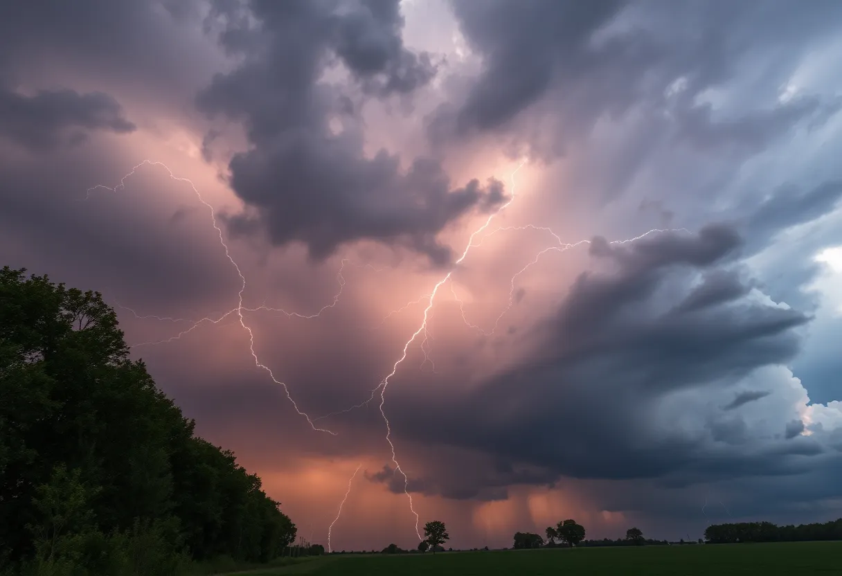
The National Weather Service has issued a thunderstorm alert for Rowan and Cabarrus Counties. Residents are advised to take cover due to expected wind gusts of up to 40 mph and possible pea-sized hail. The storm is moving quickly and may impact local communities, including Concord and Mt Pleasant. Safety guidelines recommend seeking shelter and securing outdoor items. Drivers should also be cautious of hydroplaning due to heavy rain. The alert remains in effect until noon, urging residents to stay informed and prioritizing safety.
Thunderstorm Alert in Rowan and Cabarrus Counties! Stay Safe!
Attention residents of Cabarrus and Rowan counties! It’s time to take this weather seriously as the National Weather Service has issued a thunderstorm alert this Saturday morning that could really pack a punch. This alert was first issued at 7:16 a.m. and is effective until 7:45 a.m. So, what should you know? Let’s break it down!
What’s Happening?
Doppler radar has picked up a strong thunderstorm approximately 9 miles east of downtown Concord, right around the charming area of Mt Pleasant. This storm is moving swiftly to the east at about 40 miles per hour, which means it’s on the move! If you live in or around towns like Gold Hill, Rockwell, High Rock, and of course, High Rock Lake, you could be looking at some significant weather activity.
What Should You Expect?
The forecast indicates possible wind gusts reaching up to 40 mph, along with pea-sized hail, which is about 0.25 inches in diameter. These gusty winds may knock down tree limbs and blow around unsecured items, so it’s best to secure anything that might get tossed around. If you have outdoor decorations or anything light, this is the perfect time to bring them inside!
Safety First!
Listen up, everyone! If you find yourself outdoors during the storm, the NWS recommends you seek shelter in a sturdy building. It’s not just about the wind and hail; the thunderstorms bring lightning too. Did you know that lightning strikes the U.S. about 25 million times each year? Most of those strikes occur during the summer months, making this time of year particularly risky. On average, lightning kills 20 people each year in the U.S.
Thunderstorm Precautions
As the thunderstorm creeps closer, the chances of lightning increase and peak just when the storm rolls overhead. So if you hear thunder, it’s a good time to head indoors! Once the storm starts to pass, the risk of lightning decreases, so hang tight for a bit until things settle down.
Watch Out for Hydroplaning!
While we’re on the subject of storms, let’s not forget about driving safety! Heavy rain can lead to a situation called hydroplaning, where your vehicle might uncontrollably slide on wet roads due to water buildup. Factors like worn-out tires, the depth of standing water, and how fast you’re driving can all contribute to hydroplaning. So if you’re out and about, keep an extra eye on the road and decrease your speed to stay safe!
What’s Next?
The severe thunderstorm watch for the Piedmont of North Carolina remains in effect until noon today, so keep your ears open and your phone handy for any updates. In the meantime, it’s wise to keep your head on a swivel and be cautious while navigating the roads or enjoying your time outdoors. Safety is the name of the game during these wild weather events!
So there you have it, folks! A little storm isn’t going to stop us, but it’s always better to be prepared and informed. Stay smart, stay safe, and keep an eye on the skies!
Deeper Dive: News & Info About This Topic
HERE Resources
Severe Thunderstorms Brewing in Upstate South Carolina
Severe Weather Alerts Issued for Columbia Residents
Severe Weather Disrupts Carolinas and Georgia
NC State Women’s Cross Country Team Wins Eighth Regional Title
Severe Thunderstorm Alert Shakes Up Chesterfield County
Severe Thunderstorm Warnings in South Carolina and Georgia
Thunderstorm Warnings Light Up Lowcountry Night Sky
Severe Thunderstorm Warning Hits Chester County
Madison Welcomes New Faces and Projects
Severe Thunderstorm Alert Issued for York County
Additional Resources
- WBTV: Concord, North Carolina Forecast
- Wikipedia: Thunderstorm
- NBC Boston: Lexington and Concord Weekend Forecast
- Google Search: Thunderstorm Safety
- The Weather Channel: Concord Ontario 10-Day Forecast
- Encyclopedia Britannica: Lightning
- Patch: Concord Under Flood Watch
- Google News: Thunderstorm Alert
Author: STAFF HERE ROCK HILL
The ROCK HILL STAFF WRITER represents the experienced team at HERERockHill.com, your go-to source for actionable local news and information in Rock Hill, York County, and beyond. Specializing in "news you can use," we cover essential topics like product reviews for personal and business needs, local business directories, politics, real estate trends, neighborhood insights, and state news affecting the area—with deep expertise drawn from years of dedicated reporting and strong community input, including local press releases and business updates. We deliver top reporting on high-value events such as the Come-See-Me Festival, Rock Hill Arts Festival, and motorsport events at the Rock Hill Velodrome. Our coverage extends to key organizations like the Rock Hill Chamber of Commerce and the Culture & Heritage Museums, plus leading businesses in manufacturing and technology that power the local economy such as 3D Systems and Comporium. As part of the broader HERE network, including HEREAiken.com, HEREBeaufort.com, HEREChapin.com, HERECharleston.com, HEREClinton.com, HEREColumbia.com, HEREGeorgetown.com, HEREGreenwood.com, HEREGreenville.com, HEREHiltonHead.com, HEREIrmo.com, HEREMyrtleBeach.com, HERENewberry.com, HERERockHill.com, and HERESpartanburg.com, we provide comprehensive, credible insights into South Carolina's dynamic landscape.